Toggle navigation
LMEC Home
Exhibitions
Georeferencing
Tools for Teachers
Collections
My Favorites
Sign Up / Log In
Search
Search the map portal
Map Collection
Map Collection
Map Sets
Search
Search
Search for
Search In
All Fields
Creator
Title
Subject
Place
Search All Digital Collections
Advanced Search
111 Results
My Search
Start Over
More Like
commonwealth-oai:4t64mk092
Remove constraint More Like: commonwealth-oai:4t64mk092
Place
Quebec
Remove constraint Place: Quebec
Filter your Search
Place
Canada
111
North and Central America
111
Quebec
[remove]
111
Saint Lawrence River
40
Québec
22
United States
18
Sept Iles
13
Chaudière, Rivière
12
more
Place
»
Topic
United States--History--French and Indian War, 1754-1763--Maps
69
Saint Lawrence River--Maps
40
Québec (Québec)--Maps
21
Sept-Iles (Québec)--Maps
13
Chaudière River (Québec)--Maps
12
Longue-Pointe (Québec)--Maps
12
Mingan Islands (Québec)--Maps
12
Saguenay River (Québec)--Maps
12
more
Topic
»
Date
Date range begin
–
Date range end
Current results range from
1744
to
1799
1744 : 1800
1744
1800
View distribution
Creator
Jefferys, Thomas, -1771
13
Cook, James, 1728-1779
12
Desjardins, pilot of Québec
12
Holland, Samuel, 1728-1801
12
Robert Sayer and John Bennett (Firm)
12
Saunders, Charles, Sir, 1713?-1775
12
Montrésor, John, 1736-1799
8
Haldimand, Frederick, Sir, 1718-1791
5
more
Creator
»
Format
Maps/Atlases
110
Documents
1
Georeferenced
No
111
Collection
American Revolutionary War-Era Maps
111
William L. Clements Library Collection
111
Search Constraints
Sort by relevance
relevance
title
date (asc)
date (desc)
Number of results to display per page
20 per page
10
per page
20
per page
50
per page
100
per page
View results as:
grid view
map view
Search Results
1.
Carte du gouvernement de Montréal
2.
The Cedres
3.
Channels around the Island of Orleans
4.
Continuation of the Grande Riviere with the village of Fariole lying near Cape Torment on the north shore
5.
Continuation of the River Chaudière &c.
6.
Continuation of the River Chaudière from where it falls into the St. Lawrence, as laid down in the lower plan, to the village...
7.
Continuation of the River Chaudière joining to A
8.
Continuation of the River Chaudière joining to B
9.
A correct plan of the environs of Quebec, and of the battle fought on the 13th September, 1759 : together with a particular...
10.
A draught of a route from Québec to Fort Halifax on the River Kennebec and back again to Québec by the rivers Chaudière and...
11.
Explanation of the references
12.
French draught of Lake Champlain & Lake George with remarks of an English prisoner who return'd from Quebec to Fort Edward by...
13.
Gaspee Bay
14.
Grund riss de Americanischen insuln Cape Breton, St. Iean und Anticosti im Flusse S. Laurencii
15.
Hare Island; Pointe aux Allouettes of Larks Point; English Bank
16.
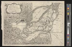
The isles of Montreal, as they have been survey'd by the French engineers
17.
Lake Megantic and the Chaudière River : Québec July 25th, 1761
18.
Manicouagan Shoals; Havre St. Nicholas; Bay of the Seven Islands
19.
Moosehead Lake and the immediate area to the west : Québec July 25th, 1761
20.
A new and accurate map of the English empire in North America : representing their rightful claim as confirm'd by charters, and...
‹ Prev
Next ›
1
2
3
4
5
6