Toggle navigation
LMEC Home
Exhibitions
Georeferencing
Tools for Teachers
Collections
My Favorites
Sign Up / Log In
Search
Search the map portal
Map Collection
Map Collection
Map Sets
Search
Search
Search for
Search In
All Fields
Creator
Title
Subject
Place
Search All Digital Collections
Advanced Search
60 Results
My Search
Start Over
More Like
commonwealth-oai:gb19k5349
Remove constraint More Like: commonwealth-oai:gb19k5349
Place
Pennsylvania
Remove constraint Place: Pennsylvania
Filter your Search
Place
North and Central America
60
Pennsylvania
[remove]
60
United States
60
Maryland
12
Virginia
9
Allegheny (county)
8
Philadelphia
8
Philadelphia (county)
8
more
Place
»
Topic
Pennsylvania--Maps
19
United States--History--Revolution, 1775-1783--Maps
17
United States--History--French and Indian War, 1754-1763--Maps
14
Braddock's Campaign, 1755--Maps
7
Maryland--Maps
7
Delaware--Maps
6
Philadelphia (Pa.)--Maps
6
Philadelphia Campaign, 1777-1778--Maps
6
more
Topic
»
Date
Date range begin
–
Date range end
Current results range from
1754
to
1801
1754 : 1802
1754
1802
View distribution
Creator
Jefferys, Thomas, -1771
7
Orme, Robert, -1781
6
Heart, Jonathan, 1748-1791
5
André, John, 1751-1780
3
Hutchins, Thomas, 1730-1789
3
Rocque, Mary Ann
3
Hills, John, active 1777-1819
2
Montrésor, John, 1736-1799
2
more
Creator
»
Format
Maps/Atlases
58
Drawings/Illustrations
2
Georeferenced
No
60
Collection
American Revolutionary War-Era Maps
60
William L. Clements Library Collection
60
Search Constraints
Sort by relevance
relevance
title
date (asc)
date (desc)
Number of results to display per page
20 per page
10
per page
20
per page
50
per page
100
per page
View results as:
grid view
map view
Search Results
1.
Fort Bedford
2.
Ein grund-ris von der Festung Duquesne ...
3.
A map of the country between Will's Creek & Monongahela River shewing the rout and encampments of the English army, in 1755
4.
Plan of Fort le Quesne, built by the French at the fort of the Ohio and monongahela in 1754
5.
A plan of Fort Ligonier done by Theodosius McDonald for George Morton : February 8th annoque domini 1760
6.
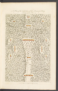
A plan of the disposition of the advanced party, consisting of 400 men
7.
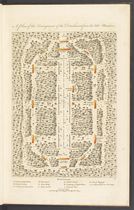
A plan of the encampment of the detachment from the Little Meadows
8.
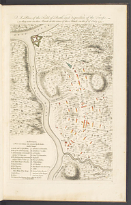
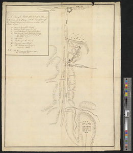
A plan of the field of battle and disposition of the troops, as they were on the march at the time of the attack on the 9th of...
9.
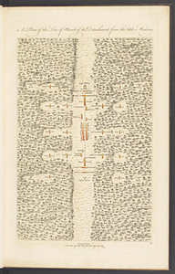
A plan of the line of march of the detachment from the Little Meadows
10.
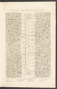
A plan of the line of march with the whole baggage
11.
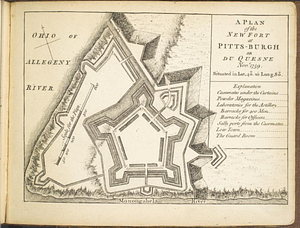
A plan of the new fort at Pitts-Burgh or Du Quesne Novr. 1759 : situated in lat. 40 20' long. 80
12.
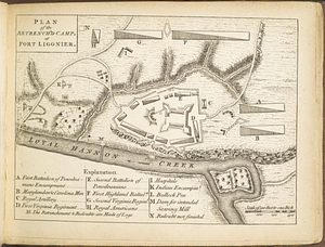
Plan of the retrench'd camp, at Fort Ligonier
13.
A rough sketch of the field of battle, near Turtle Creek, of the 9th July, with the disposition of the British troops, and...
14.
Sketch of the country from Fort Du Quesne to Niagara as described by an intelligent Indian who had resided there for a...
15.
American camp at Valley Forge
16.
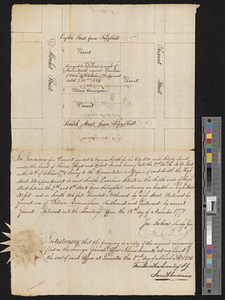
Block between Sixteenth and Seventeenth Streets and Chestnut and Market Streets, Philadelphia, 1771
17.
Burlington, New Jersey, and Bristol, Pennsylvania
18.
A chorographical map of the country round Philadelphia = Carte particuliere des environs de Philadelphia
19.
A compleat plan of part of the province of Pennsylvania East and West Jersey shewing the transactions of the royal army under...
20.
Delaware Bay and Chesapeake Bay
+
-
Redo search here
Search when I move the map
Leaflet
| ©
OpenStreetMap
contributors, ©
CartoDB
‹ Prev
Next ›
1
2
3