Toggle navigation
LMEC Home
Exhibitions
Georeferencing
Tools for Teachers
Collections
My Favorites
Sign Up / Log In
Search
Search the map portal
Map Collection
Map Collection
Map Sets
Search
Search
Search for
Search In
All Fields
Creator
Title
Subject
Place
Search All Digital Collections
Advanced Search
194 Results
My Search
Start Over
More Like
commonwealth-oai:n8713k798
Remove constraint More Like: commonwealth-oai:n8713k798
Place
New York
Remove constraint Place: New York
Filter your Search
Place
New York
[remove]
194
North and Central America
194
United States
194
Westchester (county)
26
Manhattan
17
Hudson River
15
Long Island
15
Richmond (county)
15
more
Place
»
Topic
United States--History--Revolution, 1775-1783--Maps
82
United States--History--French and Indian War, 1754-1763--Maps
46
New York (State)--Maps
24
Westchester County (N.Y.)--Maps
18
Manhattan (New York, N.Y.)--Maps
17
Hudson River (N.Y. and N.J.)--Maps
15
Long Island (N.Y.)--Maps
15
Staten Island (New York, N.Y.)--Maps
15
more
Topic
»
Date
Date range begin
–
Date range end
Current results range from
1700
to
1829
1700 : 1830
1700
1830
View distribution
Creator
Rocque, Mary Ann
20
André, John, 1751-1780
6
Clinton, Henry, Sir, 1738?-1795
6
Holland, Samuel, 1728-1801
6
Martin, Reinhard Jacob
6
Ratzer, Bernard
5
Montrésor, John, 1736-1799
4
Thompson, Alexander (Surveyor)
4
more
Creator
»
Format
Maps/Atlases
193
Drawings/Illustrations
1
Prints
1
Georeferenced
No
194
Collection
American Revolutionary War-Era Maps
192
William L. Clements Library Collection
192
Norman B. Leventhal Map & Education Center Collection
2
Available to use
No known restrictions
2
Search Constraints
Sort by relevance
relevance
title
date (asc)
date (desc)
Number of results to display per page
20 per page
10
per page
20
per page
50
per page
100
per page
View results as:
grid view
map view
Search Results
1.
Carte générale des États-Unis de l'Amérique avec les plans des principales villes
2.
The city of New York as laid out by the Commissioners with the surrounding country
3.
15 lots of 440a each in Great Lot no. 4 of Macomb purchase : 6600 acres within 2 miles of the St. Lawrence Turnpike & 1/2 mile...
4.
An accurate map of New York in North America from a late survey
5.
Admiral George Clinton's lands in the "Oblong"
6.
Attaques des forts de Chouaguen en Amérique pris par les français commandés par le Marquis de Montcalm le 14 Août 1756
7.
Attaques des retranchemens devant le fort Carillon en Amérique par les anglais commandés par le général Abercrombie contre les...
8.
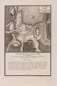
Attaques du fort William-Henri en Amérique par les troupes français aux ordres du Marquis de Montcalm prise de ce fort le 7...
9.
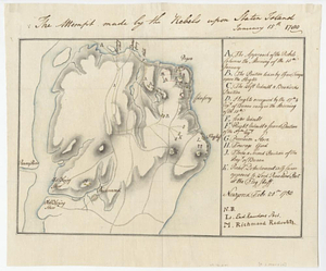
The attempt made by the rebels upon Staten Island January 15th 1780
10.
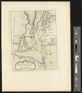
Baye et port d'Yorc capitale de la Nouvelle Yorc
11.
Bedford &c.
12.
Blackwell's Island
13.
Bridge from Staten Island to the Jersies, by Cn. Laird's description
14.
British attack upon Ticonderoga, July 7 & 8, 1758
15.
British troop dispositions in and near New York City
16.
British troop dispositions in and near New York City, July and August 1781
17.
British troop dispositions in and near New York City, Sept. 2d 1781
18.
A chorographical map of the northern department of North-America : drawn from the latest and most accurate observations
19.
Ye commencement for draft of New York Island
20.
The Delancey lands on Manhattan Island
+
-
Redo search here
Search when I move the map
Leaflet
| ©
OpenStreetMap
contributors, ©
CartoDB
‹ Prev
Next ›
1
2
3
4
5
…
9
10