Toggle navigation
LMEC Home
Exhibitions
Georeferencing
Tools for Teachers
Collections
My Favorites
Sign Up / Log In
Search
Search the map portal
Map Collection
Map Collection
Map Sets
Search
Search
Search for
Search In
All Fields
Creator
Title
Subject
Place
Search All Digital Collections
Advanced Search
25 Results
My Search
Start Over
More Like
commonwealth-oai:js95bg08k
Remove constraint More Like: commonwealth-oai:js95bg08k
Creator
Holland, Samuel, 1728-1801
Remove constraint Creator: Holland, Samuel, 1728-1801
Filter your Search
Place
North and Central America
25
Canada
16
United States
13
Quebec
12
New York
6
Québec
6
Maine
5
Saint Lawrence River
4
more
Place
»
Topic
Québec (Québec)--Maps
6
Québec Citadel (Quebec)--Maps
6
United States--History--Revolution, 1775-1783--Maps
6
Saint Lawrence River--Maps
4
Chaudière River (Québec)--Maps
3
Maine--Maps
3
Richelieu River (N.Y. and Vt-Québec)--Maps
3
Brookhaven (N.Y.)--Maps
2
more
Topic
»
Date
Date range begin
–
Date range end
Current results range from
1761
to
1779
1761 : 1780
1761
1780
View distribution
Creator
Holland, Samuel, 1728-1801
[remove]
25
Goldfrap, John George
4
Montrésor, John, 1736-1799
3
Sproule, Geo. F. (George F.), 1741-1817
3
Des Barres, Joseph F. W. (Joseph Frederick Wallet), 1729-1824
2
Fusier, Lewis
1
Haldimand, Frederick, Sir, 1718-1791
1
Morvat, Henry
1
more
Creator
»
Format
Maps/Atlases
25
Georeferenced
No
25
Collection
American Revolutionary War-Era Maps
25
William L. Clements Library Collection
25
Search Constraints
Sort by relevance
relevance
title
date (asc)
date (desc)
Number of results to display per page
20 per page
10
per page
20
per page
50
per page
100
per page
View results as:
grid view
map view
Search Results
1.
The coast from St. Johns, New Brunswick, to Goldsborough Bay, Maine
2.
The coast of Maine from modern Portland to Desert Island
3.
Penobscot Bay
4.
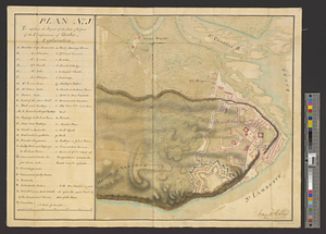
Plan and project, for fortifying the high commanding ground at the church of Deschambeaux as also the island of Richlieu [sic]
5.
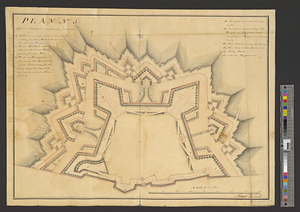
Plan (no. 1) To explain the report of the state of defence of the fortifications of Quebec
6.
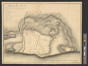
Plan (no. 2) shewing the ground whereon the citadel is proposed to be built : the ground lines of the present fortifications...
7.
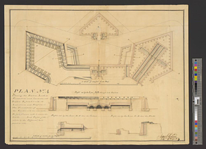
Plan (no. 3) of the citadel compleatly finished
8.
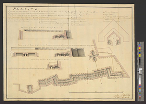
Plan no. 4 shewing the bastion A with its foundations and casemates and bastion B finish'd with its ambrazures and platforms C...
9.
Plan (no. 5) shewing the half bastion C with its foundations and the rampart towards the river side, as far as the loop-hole...
10.
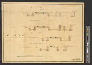
Plan no. 6 shewing the profils cut thro' the different works by the yellow lines seen on plan no. 3
11.
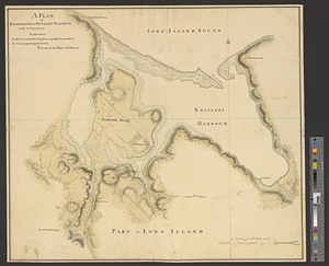
A plan of Brookhaven or Setalket Harbour with its environs
12.
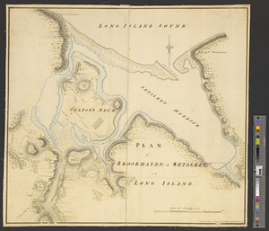
Plan of Brookhaven, or Setalket on Long Island
13.
Plan of Merritck [sic] in the township of Southold on Long Island
14.
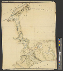
A plan of Merritick in the township of Southold on Long Island
15.
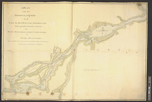
A plan of part of the province of Quebec from the Lake de Deux Montagne to River Batiscant made agreeable to the orders &...
16.
A plan of part of the province of Quebec from the river St. Anne to the island of Coudre made agreeable to the orders and...
17.
Plan of that part of Canada and the River St. Lawrence which lies between Point du Lac and Repentigny on the north shore &...
18.
A plan of the harbour of Louisbourg with the adjacent country survey'd by Samuel Holland esqr. surveyer [sic] general for the...
19.
A plan of the island of Cape Britain reduced from the large survey made by the orders and instructions of the right honorable...
20.
A plan of the Magdelain, Brion, Bird and Entry islands reduced from the large survey made agreable to the orders and...
+
-
Redo search here
Search when I move the map
Leaflet
| ©
OpenStreetMap
contributors, ©
CartoDB
‹ Prev
Next ›
1
2


![Plan and project, for fortifying the high commanding ground at the church of Deschambeaux as also the island of Richlieu [sic]](https://bpldcassets.blob.core.windows.net/derivatives/metadata/commonwealth-oai:pz50mt24s/image_thumbnail_300.jpg)
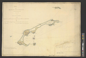
![Plan of Merritck [sic] in the township of Southold on Long Island](https://bpldcassets.blob.core.windows.net/derivatives/metadata/commonwealth-oai:8623ns35f/image_thumbnail_300.jpg)

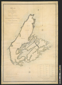
![A plan of the harbour of Louisbourg with the adjacent country survey'd by Samuel Holland esqr. surveyer [sic] general for the northern district of North America](https://bpldcassets.blob.core.windows.net/derivatives/metadata/commonwealth-oai:fx71fk83p/image_thumbnail_300.jpg)