Toggle navigation
LMEC Home
Exhibitions
Georeferencing
Tools for Teachers
Collections
My Favorites
Sign Up / Log In
Search
Search the map portal
Map Collection
Map Collection
Map Sets
Search
Search
Search for
Search In
All Fields
Creator
Title
Subject
Place
Search All Digital Collections
Advanced Search
26 Results
My Search
Start Over
More Like
commonwealth-oai:x633k0531
Remove constraint More Like: commonwealth-oai:x633k0531
Collection
Norman B. Leventhal Map & Education Center Collection
Remove constraint Collection: Norman B. Leventhal Map & Education Center Collection
Filter your Search
Place
North and Central America
26
United States
26
New Jersey
18
Pennsylvania
6
Massachusetts
5
Boston
4
Middle Atlantic
4
Suffolk (county)
4
more
Place
»
Topic
New Jersey--Maps
19
United States--History--Revolution, 1775-1783--Maps
8
Pennsylvania--Maps
6
New York (State)--Maps
4
Boston (Mass.)--History--Revolution, 1775-1783--Maps
3
Middle Atlantic States--Maps
3
Railroads--New Jersey--Maps
3
Counties--New Jersey--Maps
2
more
Topic
»
Date
Date range begin
–
Date range end
Current results range from
1777
to
1909
1777 : 1910
1777
1910
View distribution
Creator
Geological Survey of New Jersey
5
United States. Post Office Dept
3
Carey, Mathew, 1760-1839
2
MacNair, Henry.
2
Barker, W. (William), active 1795-1803
1
Blaisdell, H. W.
1
Cook, George Hammell, 1818-1889
1
Crissy, James
1
more
Creator
»
Format
Maps/Atlases
26
Manuscripts
1
Georeferenced
Yes
13
No
13
Collection
Norman B. Leventhal Map & Education Center Collection
[remove]
26
Boston and New England Maps
5
American Revolutionary War-Era Maps
3
Urban Maps
3
Available to use
No known restrictions
26
Search Constraints
Sort by relevance
relevance
title
date (asc)
date (desc)
Number of results to display per page
20 per page
10
per page
20
per page
50
per page
100
per page
View results as:
grid view
map view
Search Results
1.
Map of American camp in New Jersey and surrounding countryside
2.
An historical map of Pennsylvania : showing the Indian names of streams and villages, and paths of travel : the sites of old...
3.
Manuscript maps of U.S. states, possibly drawn by a schoolchild
4.
Map of the canals and rail roads for transporting anthracite coal from the several coal fields to the city of New York
5.
Map of the rail roads of New Jersey 1887
6.
Map of the State of New York with part of the states of Pennsylvania, New Jersey &c
7.
New Jersey
8.
New Jersey showing forest area and its relation to the principal watersheds
9.
Northern New Jersey, showing the iron-ore & limestone districts
10.
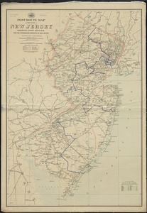
Post route map of the State of New Jersey showing post offices with the intermediate distances on mail routes in operation on...
11.
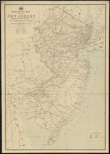
Post route map of the state of New Jersey showing post offices with the intermediate distances on mail routes in operation on...
12.
Post route map of the states of Pennsylvania, New Jersey, Delaware, and Maryland and of the District of Columbia with adjacent...
13.
Rand, McNally & Co.'s New Jersey
14.
Relief map of New Jersey
15.
The State of New Jersey : from original surveys based on the triangulation of the U.S. Coast and Geodetic Survey
16.
The state of New Jersey : economic geology
17.
The state of New Jersey, compiled from the most authentic information
18.
A survey of the empire group : with a complete distance table, a compendious index of cities and post offices, with populations...
19.
A survey of the empire group : with a complete distance table, a compendious index of cities and post offices, with populations...
20.
Atlas to Marshall's life of Washington
‹ Prev
Next ›
1
2