Toggle navigation
LMEC Home
Exhibitions
Georeferencing
Tools for Teachers
Collections
My Favorites
Sign Up / Log In
Search
Search the map portal
Map Collection
Map Collection
Map Sets
Search
Search
Search for
Search In
All Fields
Creator
Title
Subject
Place
Search All Digital Collections
Advanced Search
13694 Results
Filter your Search
Place
North and Central America
10,357
United States
8,484
Massachusetts
2,796
Suffolk (county)
1,678
Boston
1,634
Europe
1,419
Canada
950
New York
650
more
Place
»
Topic
Boston (Mass.)--Maps
748
City planning--Massachusetts--Boston--Maps
418
United States--History--Revolution, 1775-1783--Maps
329
United States--Maps
322
Real property--Massachusetts--Boston--Maps
254
Urban renewal--Massachusetts--Boston--Maps
254
Massachusetts--Maps
233
Insurance surveys
197
more
Topic
»
Date
Date range begin
–
Date range end
Current results range from
1482
to
2023
View distribution
Creator
United States. Hydrographic Office
597
Boston Redevelopment Authority
404
Des Barres, Joseph F. W. (Joseph Frederick Wallet), 1722-1824
247
Royal United Services Institute for Defence and Security Studies
160
Jefferys, Thomas, -1771
154
George, III, King of Great Britain, 1738-1820
152
George, IV, King of Great Britain, 1762-1830
151
O.H. Bailey & Co
148
more
Creator
»
Format
Maps/Atlases
13,513
Manuscripts
985
Prints
102
Books
49
Drawings/Illustrations
44
Photographs
15
Objects/Artifacts
13
Documents
7
more
Format
»
Georeferenced
Yes
979
No
12,715
Collection
Norman B. Leventhal Map & Education Center Collection
9,108
American Revolutionary War-Era Maps
3,305
Boston and New England Maps
2,921
Urban Maps
2,480
Maritime Charts and Atlases
1,169
William L. Clements Library Collection
910
Library of Congress Collection
618
Boston Redevelopment Authority Collection
475
more
Collection
»
Available to use
No known restrictions
10,260
Creative Commons license
1,678
Search Constraints
Sort by relevance
relevance
title
date (asc)
date (desc)
Number of results to display per page
20 per page
10
per page
20
per page
50
per page
100
per page
View results as:
grid view
map view
Search Results
13661.
Yellow Sea, west coast of Korea, A-San Anchorage : from a Japanese government survey in 1879
13662.
Yellowstone National Park : from surveys made under the direction of F.V. Hayden and other authorities
13663.
Yellowstone National Park, Big Horn Mountains and adjacent territory
13664.
Yeojido
13665.
Yggdrasill, the mundane tree
13666.
York en Virginie, 1781 : Carte des environs d'York avec les attaques à la position des Armées francaise et americaine devant...
13667.
York Town, and Gloucester Point : as besieged by the Allied Army
13668.
Yorktown, Virginia, and the surrounding area, ca. 1781
13669.
Yosemite Valley
13670.
Ypra
13671.
Ysla de Cuba
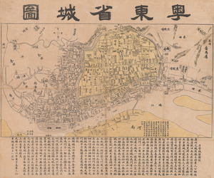
13672.
Yuedong sheng chengtu
13673.
Yuenan renmin kang mei jiu guo xing shi tu
13674.
Y.W.C.A. war work centers in the United States
13675.
Zambales
13676.
Zeilan Insula
13677.
Železnička i brodarska karta Kraljevine Srba Hrvata i Slovenaca = Carte des chemins de fer et de naviation du Royaume des...
13678.
Zentral- und Südafrika
13679.
Die zerstörung der königlichen bild säule zu Neu Yorck = : La destruction de la statue royale a Nouvelle Yorck
13680.
Zhongguo di zhi tu = General geological map of China : Peking-Tsinan Sheet
‹ Prev
Next ›
1
2
…
680
681
682
683
684
685