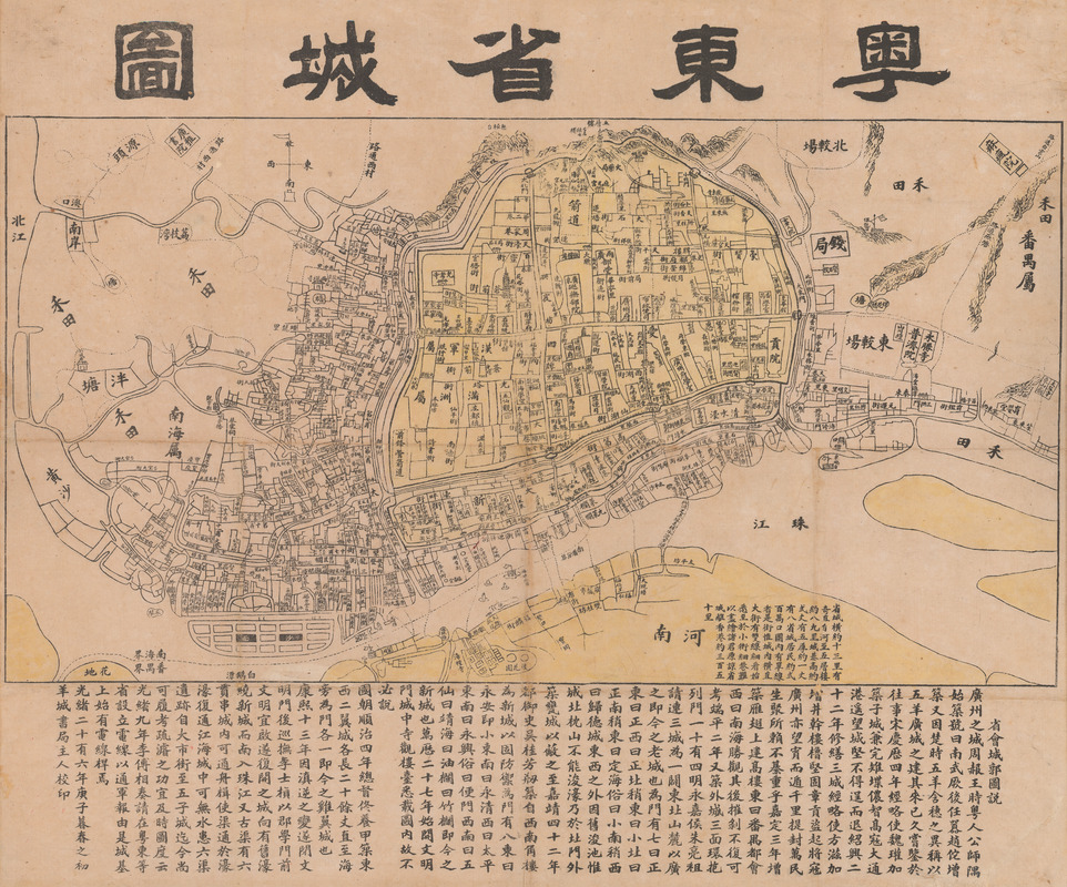
Yuedong sheng chengtu
Item Information
- Title:
- Yuedong sheng chengtu
- Title (alt.):
-
Map of Guangzhou
- Description:
-
The map title uses the ancient name for the southern region of China, Yue. The title translates something like “map of the city of the province in eastern Yue,” today’s Guangzhou (Canton) in Guangdong province. It is dated to the twenty-sixth year of the Guangxu reign of the Qing dynasty (1900). A section of the Pearl River meanders along the bottom of the map. Above that the section in yellow is the old walled part of the city. The large body of text below provides a history of the naming of this provincial capital city and the region. Another smaller block of text provides information about the physical characteristics of the city. Historically maps in Chinese were produced by the central or regional governments. During the nineteenth century, several bilingual, for example English and Chinese, maps of Canton (Guangzhou) were produced by Western publishers. This map is unusual in that it was one of the first published using only Chinese characters by a local commercial enterprise, the Yangcheng bookstore.
- Date:
-
1900
- Format:
-
Maps/Atlases
Manuscripts
- Location:
- MacLean Collection Map Library
- Collection (local):
-
MacLean Collection Map Library
- Subjects:
-
Guangzhou (China)--Maps
- Places:
-
Canton (province)Canton
- Extent:
- 1 map : color ; 51 cm x 62 cm
- Terms of Use:
-
Public Domain/No known restrictions on use. Contact host institution to download image.
Contact host institution for more information.
- Publisher:
-
Guangdong (Canton) :
Yangcheng Bookstore
- Scale:
-
Scale 1:10,000
- Language:
-
Chinese
- Notes:
-
This is a rare Qing Dynasty era Guangxu 26 or 1900 Chinese map of Guangzhou or Canton printed in Guangzhou by the Yangcheng Bookstore (澄天阁点石 / 澄天閣點石書局).
It is one of the earliest known examples of Chinese commercial cartography.
The map is oriented to the north, looking at the city of Guangzhou from the south side of the Pearl River.
The city walls and low mountains are apparent in the distance.
Dotted lines on the Pearl Liver indicate river crossings and routes to Haudi (花地).
At the base of the map, extensive textual annotation in Chinese describes the development of the city.
Manuscript, ink on paper.
- Identifier:
-
MacLeanColl_36112_Guangzhou
- Call #:
-
36112