Toggle navigation
LMEC Home
Exhibitions
Georeferencing
Tools for Teachers
Collections
My Favorites
Sign Up / Log In
Search
Search the map portal
Map Collection
Map Collection
Map Sets
Search
Search
Search for
Search In
All Fields
Creator
Title
Subject
Place
Search All Digital Collections
Advanced Search
13414 Results
Filter your Search
Place
North and Central America
10,140
United States
8,278
Massachusetts
2,718
Suffolk (county)
1,664
Boston
1,621
Europe
1,386
Canada
949
New York
640
more
Place
»
Topic
Boston (Mass.)--Maps
742
City planning--Massachusetts--Boston--Maps
418
United States--History--Revolution, 1775-1783--Maps
329
United States--Maps
315
Urban renewal--Massachusetts--Boston--Maps
254
Real property--Massachusetts--Boston--Maps
252
Massachusetts--Maps
224
Insurance surveys
197
more
Topic
»
Date
Date range begin
–
Date range end
Current results range from
1482
to
2023
View distribution
Creator
United States. Hydrographic Office
595
Boston Redevelopment Authority
403
Des Barres, Joseph F. W. (Joseph Frederick Wallet), 1722-1824
247
Royal United Services Institute for Defence and Security Studies
160
Jefferys, Thomas, -1771
154
George, III, King of Great Britain, 1738-1820
152
George, IV, King of Great Britain, 1762-1830
151
O.H. Bailey & Co
148
more
Creator
»
Format
Maps/Atlases
13,234
Manuscripts
985
Prints
102
Books
49
Drawings/Illustrations
44
Photographs
15
Objects/Artifacts
13
Documents
7
more
Format
»
Georeferenced
Yes
979
No
12,435
Collection
Norman B. Leventhal Map & Education Center Collection
8,920
American Revolutionary War-Era Maps
3,305
Boston and New England Maps
2,833
Urban Maps
2,402
Maritime Charts and Atlases
1,150
William L. Clements Library Collection
910
Library of Congress Collection
618
Boston Redevelopment Authority Collection
475
more
Collection
»
Available to use
No known restrictions
9,981
Creative Commons license
1,677
Search Constraints
Sort by relevance
relevance
title
date (asc)
date (desc)
Number of results to display per page
20 per page
10
per page
20
per page
50
per page
100
per page
View results as:
grid view
map view
Search Results
401.
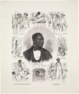
Anthony Burns
402.
Antietam
403.
Antietam Sharpsburg and vicinity : constructed and engraved to illustrate "The war with the South"
404.
Antigoa
405.
Antigua
406.
Antigue : levée par Robert Baker, Arpenteur General de l'Isle ; traduit de l'Anglais
407.
Antilles ou Indes Occidentales
408.
Antrim, N.H. and Clinton Village : 1887
409.
Antwerp : or Anvers
410.
Apia, Apaiang or Charlotte Island, Kingsmill Group ; Cook Island, Tarawa or Knox Island, Kingsmill Group
411.
Apolima, Samoan Group ; Harbour of Oafonu, Isld. of Tutuila, north side ; Harbour of Aur, Isld. of Tutuila, north side ;...
412.
Apolima, Samoan Group ; Harbour of Oafonu, Isld. of Tutuila, north side ; Hübner Bay, Island of Tutuila ; Harbour of Aur,...
413.
Appearance of Fort Sumter on Sunday afternoon, August 23d, 1863 : sketched from the "Beacon house" on Morris Island
414.
Appearance of the land from the White Islands to St. Marys River taken two leagues off shore : The entrance of Milford Haven at...
415.
Appleton St. Woonerf
416.
Appletons' railway map of the United States and Canada
417.
Appletons' railway map of the United States and the Canadas : representing railways in actual operation, and those in the...
418.
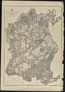
Appomattox Court House
419.
Approach to Ta-Tong River, west coast Corea
420.
Approaches to Cohasset Harbor Mass. : topography surveyed in 1847 ; hydrography surveyed in 1846-'56
‹ Prev
Next ›
1
2
…
17
18
19
20
21
22
23
24
25
…
670
671