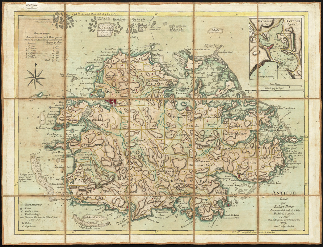
Antigue : levée par Robert Baker, Arpenteur General de l'Isle ; traduit de l'Anglais
This map is also available in American Revolutionary Geographies Online (ARGO), a collections portal especially built for material relating to the American Revolutionary War Era. Visit ARGO to learn more about this item and explore the historical geography of North America in the late eighteenth century.
Item Information
- Title:
- Antigue : levée par Robert Baker, Arpenteur General de l'Isle ; traduit de l'Anglais
- Description:
-
Barbados and Jamaica were Britain's major sugar islands, but smaller islands like Antigua also produced sugar for British markets. Based on a 1746 map by Robert Baker, the island's surveyor general, this version was republished for a French audience. The map reflects the intense competition between the French and British in the West Indies sugar trade. The map depicts roads (colored yellow) crisscrossing the island, while sugar mills powered by wind and cattle (colored red) dot the landscape. On the northern coast of the island, the area labeled "Royal's Bay" indicates where the Royall family of Medford, Massachusetts owned a sugar plantation.
- Creator:
- Le Rouge, Georges-Louis
- Contributor:
- Jefferys, Thomas, -1771
- Date:
-
1779
- Format:
-
Maps/Atlases
- Location:
- George Washington's Mount Vernon
- Collection (local):
-
Richard H. Brown Revolutionary War Map Collection at Mount Vernon
- Subjects:
-
Antigua--Maps--Early works to 1800
- Places:
-
Antigua and BarbudaAntigua (island)
- Extent:
- 1 map : hand color ; 45 x 59 cm.
- Terms of Use:
-
No known copyright restrictions.
This work is licensed for use under a Creative Commons Attribution Non-Commercial Share Alike License (CC BY-NC-SA).

- Publisher:
-
Paris :
Le Rouge
- Scale:
-
Scale [ca. 1:43,000]
- Language:
-
French
- Catalog Record:
-
MVLA record
- Notes:
-
Shows parishes, cities, settlements, roads, churches, windmills, "cattle mills," bays, anchorages, shoals and topography.
Relief shown by hachures. Depths shown by soundings.
Prime meridians: London and Ferro.
Inset: English Harbour ou Port Anglais.
Includes list of acreage of parishes and navigation notes.
Manuscript label on verso: No. 65. Isle Antigue.
This map can be viewed as a georeferenced overlay in an interactive application made especially for We Are One: Mapping America's Road from Revolution to Independence http://d2o8owo4k087al.cloudfront.net/index.html?mapId=26.
- Notes (citation):
-
LC Maps of North America, 1750-1789, 2004
- Notes (exhibitions):
-
Exhibited: "We Are One: Mapping America's Road from Revolution to Independence" organized by the Norman B. Leventhal Map Center at the Boston Public Library, 2015.
- Identifier:
-
06_01_010480
- Barcode:
-
30000003568926