Toggle navigation
LMEC Home
Exhibitions
Georeferencing
Tools for Teachers
Collections
My Favorites
Sign Up / Log In
Search
Search the map portal
Map Collection
Map Collection
Map Sets
Search
Search
Search for
Search In
All Fields
Creator
Title
Subject
Place
Search All Digital Collections
Advanced Search
2843 Results
My Search
Start Over
atlas
Remove constraint atlas
Filter your Search
Place
North and Central America
1,647
United States
987
Europe
464
Massachusetts
348
Canada
271
Asia
190
South America
189
Suffolk (county)
163
more
Place
»
Topic
Landowners--Massachusetts--Boston--Maps
115
Real property--Massachusetts--Boston--Maps
106
United States--Maps
87
Boston (Mass.)--Maps
63
United States--History--French and Indian War, 1754-1763--Maps
63
Saint Lawrence River--Maps
41
Nautical charts--Early works to 1800
39
North America--Maps--Early works to 1800
36
more
Topic
»
Date
Date range begin
–
Date range end
Current results range from
1482
to
2023
View distribution
Creator
United States. Hydrographic Office
582
Des Barres, Joseph F. W. (Joseph Frederick Wallet), 1722-1824
118
Ptolemy, 2nd cent
100
Bromley, George Washington
99
Bromley, Walter Scott
97
G.W. Bromley & Co.
75
Carey, Mathew, 1760-1839
74
Paullin, Charles Oscar, 1868 or 1869-1944
70
more
Creator
»
Format
Maps/Atlases
2,827
Manuscripts
58
Books
37
Prints
8
Documents
5
Drawings/Illustrations
1
Georeferenced
Yes
142
No
2,701
Collection
Norman B. Leventhal Map & Education Center Collection
2,386
Maritime Charts and Atlases
1,150
American Revolutionary War-Era Maps
504
Boston and New England Maps
374
Urban Maps
250
Massachusetts Real Estate Atlases
144
William L. Clements Library Collection
92
Mapping Boston Collection
61
more
Collection
»
Available to use
No known restrictions
2,292
Creative Commons license
158
Search Constraints
Sort by relevance
relevance
title
date (asc)
date (desc)
Number of results to display per page
20 per page
10
per page
20
per page
50
per page
100
per page
View results as:
grid view
map view
Search Results
2701.
Paraguay, ó, prov. de Rio de la Plata cum regionibus adiacentibus Tucuman et Sta. Cruz de la Sierra
2702.
Prima Europae tabula
2703.
Quarta Asiae taubla continet Cyprum & Syrium & Iudea & vtraq. Arabia petream & deserta ac Mesopotamia & Babilonia
2704.
Ta. mo. Galliae
2705.
Ta. mo. Germa
2706.
Ta. moder. Bossinae, Serviae, Graeciae, et Sclavoniae
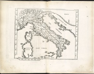
2707.
Ta. no. Italiae
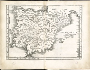
2708.
Tab. mo. Hispan
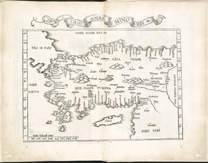
2709.
Tabu. Asiae minoris
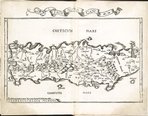
2710.
Tabu. nova Can
2711.
Tabula moder. Indiae Orientalis
2712.
Tabula moderna Hiber
2713.
Tabula moderna Italie
2714.
[World map]
2715.
Barbadoes
2716.
Carte de l'Isle de la Grenade cédée a la Grand Bretagne par le dernier traité de paix = Grenada divided into its parishes :...
2717.
Cuba Insula ; Hispaniola Insula
2718.
Curaçao
2719.
An exact chart of the river St. Laurence, from Fort Frontenac to the island of Anticosti shewing the soundings, rocks, shoals...
2720.
Guadaloupe, done from actual surveys and observations of the English : whilst the island was in their possession
‹ Prev
Next ›
1
2
…
132
133
134
135
136
137
138
139
140
…
142
143