Toggle navigation
LMEC Home
Exhibitions
Georeferencing
Tools for Teachers
Collections
My Favorites
Sign Up / Log In
Search
Search the map portal
Map Collection
Map Collection
Map Sets
Search
Search
Search for
Search In
All Fields
Creator
Title
Subject
Place
Search All Digital Collections
Advanced Search
13533 Results
Filter your Search
Place
North and Central America
10,245
United States
8,379
Massachusetts
2,783
Suffolk (county)
1,677
Boston
1,633
Europe
1,387
Canada
950
New York
644
more
Place
»
Topic
Boston (Mass.)--Maps
747
City planning--Massachusetts--Boston--Maps
418
United States--History--Revolution, 1775-1783--Maps
329
United States--Maps
321
Real property--Massachusetts--Boston--Maps
254
Urban renewal--Massachusetts--Boston--Maps
254
Massachusetts--Maps
231
Insurance surveys
197
more
Topic
»
Date
Date range begin
–
Date range end
Current results range from
1482
to
2023
View distribution
Creator
United States. Hydrographic Office
596
Boston Redevelopment Authority
404
Des Barres, Joseph F. W. (Joseph Frederick Wallet), 1722-1824
247
Royal United Services Institute for Defence and Security Studies
160
Jefferys, Thomas, -1771
154
George, III, King of Great Britain, 1738-1820
152
George, IV, King of Great Britain, 1762-1830
151
O.H. Bailey & Co
148
more
Creator
»
Format
Maps/Atlases
13,352
Manuscripts
985
Prints
102
Books
49
Drawings/Illustrations
44
Photographs
15
Objects/Artifacts
13
Documents
7
more
Format
»
Georeferenced
Yes
979
No
12,554
Collection
Norman B. Leventhal Map & Education Center Collection
9,037
American Revolutionary War-Era Maps
3,305
Boston and New England Maps
2,906
Urban Maps
2,428
Maritime Charts and Atlases
1,168
William L. Clements Library Collection
910
Library of Congress Collection
618
Boston Redevelopment Authority Collection
475
more
Collection
»
Available to use
No known restrictions
10,100
Creative Commons license
1,677
Search Constraints
Sort by relevance
relevance
title
date (asc)
date (desc)
Number of results to display per page
20 per page
10
per page
20
per page
50
per page
100
per page
View results as:
grid view
map view
Search Results
201.
Ahii and Manhii or Peacock and Wilsons Islands
202.
Ahii and Manhii or Peacock and Wilsons Islands
203.
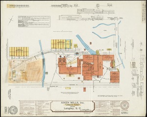
Aiken Mills, Inc. "Langley Plant" (Cotton), Langley, S.C.
204.
Airbrush base for the Pelorus Linea region of Europa
205.
Airport obstruction chart OC 58, General Edward Lawrence Logan International Airport, Boston, Massachusetts
206.
Airways of the world on Mercator's projection
207.
Aitoff's equal area projection of the sphere
208.
Ajia tōbu yochizu
209.
Alabama
210.
Alas, poor Yorick!--from the painting by Horace Fisher
211.
Alaska and adjoining region
212.
Alaska and adjoining territory
213.
Alaska and adjoining territory
214.
The Alaska Railroad
215.
Albania
216.
Albany, New York : 1879
217.
Albemarle and Pamlico Sounds
218.
Alberta and western portions of Saskatchewan and Assiniboia
219.
Alberta, southern : map showing disposition of lands
220.
Alberta, southern : map showing disposition of lands
‹ Prev
Next ›
1
2
…
7
8
9
10
11
12
13
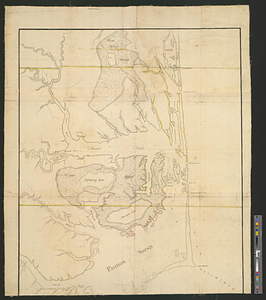
14
15
…
676
677