Toggle navigation
LMEC Home
Exhibitions
Georeferencing
Tools for Teachers
Collections
My Favorites
Sign Up / Log In
Search
Search the map portal
Map Collection
Map Collection
Map Sets
Search
Search
Search for
Search In
All Fields
Creator
Title
Subject
Place
Search All Digital Collections
Advanced Search
13694 Results
Filter your Search
Place
North and Central America
10,357
United States
8,484
Massachusetts
2,796
Suffolk (county)
1,678
Boston
1,634
Europe
1,419
Canada
950
New York
650
more
Place
»
Topic
Boston (Mass.)--Maps
748
City planning--Massachusetts--Boston--Maps
418
United States--History--Revolution, 1775-1783--Maps
329
United States--Maps
322
Real property--Massachusetts--Boston--Maps
254
Urban renewal--Massachusetts--Boston--Maps
254
Massachusetts--Maps
233
Insurance surveys
197
more
Topic
»
Date
Date range begin
–
Date range end
Current results range from
1482
to
2023
View distribution
Creator
United States. Hydrographic Office
597
Boston Redevelopment Authority
404
Des Barres, Joseph F. W. (Joseph Frederick Wallet), 1722-1824
247
Royal United Services Institute for Defence and Security Studies
160
Jefferys, Thomas, -1771
154
George, III, King of Great Britain, 1738-1820
152
George, IV, King of Great Britain, 1762-1830
151
O.H. Bailey & Co
148
more
Creator
»
Format
Maps/Atlases
13,513
Manuscripts
985
Prints
102
Books
49
Drawings/Illustrations
44
Photographs
15
Objects/Artifacts
13
Documents
7
more
Format
»
Georeferenced
Yes
979
No
12,715
Collection
Norman B. Leventhal Map & Education Center Collection
9,108
American Revolutionary War-Era Maps
3,305
Boston and New England Maps
2,921
Urban Maps
2,480
Maritime Charts and Atlases
1,169
William L. Clements Library Collection
910
Library of Congress Collection
618
Boston Redevelopment Authority Collection
475
more
Collection
»
Available to use
No known restrictions
10,260
Creative Commons license
1,678
Search Constraints
Sort by relevance
relevance
title
date (asc)
date (desc)
Number of results to display per page
20 per page
10
per page
20
per page
50
per page
100
per page
View results as:
grid view
map view
Search Results
13021.
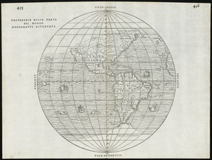
Universale della parte del mondo nuovamente ritrovata
13022.
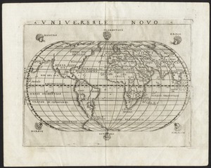
Universale novo
13023.
Universalis de terrao orarium ex vera recen [...] traditione
13024.
University and city of Oxford
13025.
Unsigned and untitled T-O world map
13026.
Upper Canada and the Great Lakes region
13027.
Upper Geyser Basin
13028.
Upper New York, Vermont, and Massachusetts
13029.
Upper Salem and part of the tounds [sic] joining it for two or three miles distance
13030.
Uprooted people of the U.S.A.
13031.
Upton, Massachusetts : 1888
13032.
Urbs et arx Mitovia sedes celsis. Curlandiae Ducis ab Exell. Dn. Campi Mareschallo Comite Duglasio occupata A. 1659 ; Dobbleena...
13033.
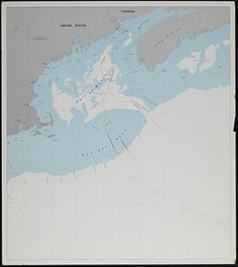
U.S. and Canadian maritime boundary claims off of the Atlantic coast
13034.
U.S. Coast Survey classification and rules for the miscellaneous lettering of names &c. on the map, not connected with title or...
13035.
U.S. North Pacific Surveying Expedition ... Amakirima Group with part of Loo-Choo by the Vincennes, John Hancock and Fenimore...
13036.
USAF cloth chart, Western Mediterranean
13037.
U.S.S. George Washington Dec. 4, 1917 - Dec. 23, 1918
13038.
Utah Gidex Utah
13039.
Utility map, Washington Park project r-24
13040.
Utriusque Alsatiae, ducatus Dupontii, et Spirensis Episcopatus novissima descriptio
‹ Prev
Next ›
1
2
…
648
649
650
651
652
653
654
655
656
…
684
685
![Universalis de terrao orarium ex vera recen [...] traditione](https://bpldcassets.blob.core.windows.net/derivatives/images/commonwealth:hq37vv39x/image_thumbnail_300.jpg)


![Upper Salem and part of the tounds [sic] joining it for two or three miles distance](https://bpldcassets.blob.core.windows.net/derivatives/metadata/commonwealth-oai:8k71sf77k/image_thumbnail_300.jpg)