Toggle navigation
LMEC Home
Exhibitions
Georeferencing
Tools for Teachers
Collections
My Favorites
Sign Up / Log In
Search
Search the map portal
Map Collection
Map Collection
Map Sets
Search
Search
Search for
Search In
All Fields
Creator
Title
Subject
Place
Search All Digital Collections
Advanced Search
5289 Results
My Search
Start Over
Date Range
before 1800
Remove constraint Date Range: before 1800
Filter your Search
Place
North and Central America
3,721
United States
2,498
Canada
655
Europe
652
Massachusetts
471
New York
376
North America
307
Maine
205
more
Place
»
Topic
United States--History--Revolution, 1775-1783--Maps
323
North America--Maps--Early works to 1800
179
United States--History--French and Indian War, 1754-1763--Maps
161
Manuscript maps--Early works to 1800
137
New England--Maps--Early works to 1800
89
World maps--Early works to 1800
76
America--Maps--Early works to 1800
73
Saint Lawrence River--Maps
63
more
Topic
»
Date
Date range begin
–
Date range end
Current results range from
1482
to
1990
View distribution
Creator
Des Barres, Joseph F. W. (Joseph Frederick Wallet), 1722-1824
245
Royal United Services Institute for Defence and Security Studies
158
Jefferys, Thomas, -1771
153
George, III, King of Great Britain, 1738-1820
152
George, IV, King of Great Britain, 1762-1830
151
Amherst, Jeffery Amherst, Baron, 1717-1797
130
Sayer, Robert, 1725-1794
107
Faden, William, 1749-1836
106
more
Creator
»
Format
Maps/Atlases
5,176
Manuscripts
787
Prints
59
Drawings/Illustrations
36
Books
11
Documents
5
Objects/Artifacts
3
Ephemera
1
Georeferenced
Yes
156
No
5,133
Collection
American Revolutionary War-Era Maps
3,277
Norman B. Leventhal Map & Education Center Collection
2,099
William L. Clements Library Collection
905
Library of Congress Collection
618
Town plans, 1794
403
British Library Collection
375
Maritime Charts and Atlases
371
Richard H. Brown Revolutionary War Map Collection at Mount Vernon
294
more
Collection
»
Available to use
No known restrictions
2,477
Creative Commons license
1,559
Search Constraints
Sort by relevance
relevance
title
date (asc)
date (desc)
Number of results to display per page
20 per page
10
per page
20
per page
50
per page
100
per page
View results as:
grid view
map view
Search Results
341.
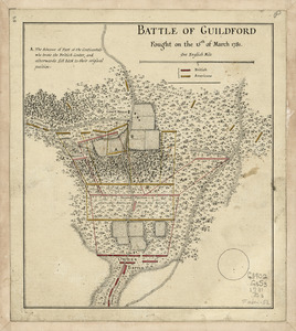
Battle of Guildford fought on the 15 of March 1781
342.
Battle of Guildford fought on the 15th of March 1781
343.
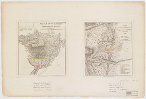
Battle of Guildford, fought on the 15th of March 1781. Plan of the batttle fought near Camden, August 16th, 1780
344.
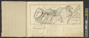
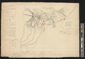
Battle of Monmouth, 28th June 1778
345.
Battle of Monmouth, 28th June 1778
346.
Battle of Zorndorf
347.
Bavariae Palatinatus vulgo die Ober-Pfaltz in subjacentes ejusdem praefecturas accuratissime divisus
348.
Bavariae pars inferior cum insertis et adjacentibus regionibus non solum in ejusdem ditiones generales sed etiam in earundem...
349.
Bavariae pars superior cum insertis et adjacentibus regionibus non solum in ejusdem ditiones genrales sed etiam in earundem...
350.
Bay Bulls
351.
Bay of Chaleurs
352.
Bay of Pensacola, fortification
353.
[Bay of Seven Islands]
354.
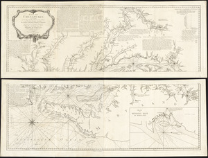
Baye de Chesapeake en 4 feuilles avec les bas fonds, passes, entrées, sondes et routes ou l'on donne les parties navigables...
355.
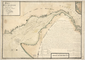
Baye de la Delaware avec les ports, sondes, dangers, bancs, &c. depuis les caps jusqu'a Philadelphie : d'après la carte de...
356.
Baye et port de Boston
357.
Baye et port de Boston
358.
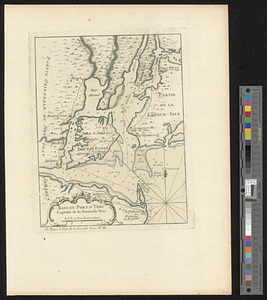
Baye et port d'Yorc capitale de la Nouvelle Yorc
359.
Baye et port d'Yorc, capitale de la Nouvelle Yorc
360.
La Beauce
‹ Prev
Next ›
1
2
…
14
15
16
17
18
19
20
21
22
…
264
265


![[Bay of Seven Islands]](https://bpldcassets.blob.core.windows.net/derivatives/images/commonwealth:7h149v48t/image_thumbnail_300.jpg)