Toggle navigation
LMEC Home
Exhibitions
Georeferencing
Tools for Teachers
Collections
My Favorites
Sign Up / Log In
Search
Search the map portal
Map Collection
Map Collection
Map Sets
Search
Search
Search for
Search In
All Fields
Creator
Title
Subject
Place
Search All Digital Collections
Advanced Search
10951 Results
My Search
Start Over
All Fields
americas
Remove constraint All Fields: americas
Filter your Search
Place
North and Central America
10,344
United States
8,469
Massachusetts
2,789
Suffolk (county)
1,675
Boston
1,631
Canada
937
New York
649
Middlesex (county)
441
more
Place
»
Topic
Boston (Mass.)--Maps
746
City planning--Massachusetts--Boston--Maps
418
United States--History--Revolution, 1775-1783--Maps
327
United States--Maps
320
Real property--Massachusetts--Boston--Maps
254
Urban renewal--Massachusetts--Boston--Maps
254
Massachusetts--Maps
231
Insurance surveys
194
more
Topic
»
Date
Date range begin
–
Date range end
Current results range from
1507
to
2023
View distribution
Creator
Boston Redevelopment Authority
404
United States. Hydrographic Office
366
Des Barres, Joseph F. W. (Joseph Frederick Wallet), 1722-1824
197
Jefferys, Thomas, -1771
150
George, III, King of Great Britain, 1738-1820
146
O.H. Bailey & Co
146
George, IV, King of Great Britain, 1762-1830
145
Royal United Services Institute for Defence and Security Studies
139
more
Creator
»
Format
Maps/Atlases
10,828
Manuscripts
916
Prints
60
Books
43
Drawings/Illustrations
43
Photographs
15
Objects/Artifacts
7
Posters
3
more
Format
»
Georeferenced
Yes
823
No
10,128
Collection
Norman B. Leventhal Map & Education Center Collection
6,627
American Revolutionary War-Era Maps
3,123
Boston and New England Maps
2,912
Urban Maps
2,289
William L. Clements Library Collection
892
Maritime Charts and Atlases
816
Library of Congress Collection
552
Boston Redevelopment Authority Collection
475
more
Collection
»
Available to use
No known restrictions
7,767
Creative Commons license
1,541
Search Constraints
Sort by relevance
relevance
title
date (asc)
date (desc)
Number of results to display per page
20 per page
10
per page
20
per page
50
per page
100
per page
View results as:
grid view
map view
Search Results
1821.
New Hampshire
1822.
Eight views of the world
1823.
A new map of Nova Scotia, and Cape Britain : with the adjacent parts of New England and Canada, composed from a great number of...
1824.
Plan of Puerto Cavello, on the coast of the Caracas ; Plan of Puerto de La Guaira on the coast of the Caracas
1825.
Plan of the city and suburbs of Carthagena ; Plan of the bay & town of Sta. Martha, on the coast of Tierra Firma
1826.
Plan of Zisapata Bay ; Plan of the harbour of Carthagena
1827.
Plano del puerto de la Havana, situado en la parte del N. de la ysla de Cuba en la lattd. de 23⁰10ʹ y en longd. astronómica de...
1828.
Havana : Vera Cruz
1829.
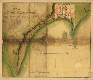
Plan de la ville du Trou Jéremie : rélatif à l'article 13 du projet géneral de défense
1830.
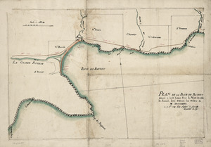
Plan de la Baye de Baynet : situeé a hiut leiues sous le vent de celle de Jacmel, levé suivant les ordres de Mr. d'Estaing le...
1831.
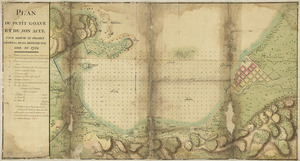
Plan du Petit Goâve et de son acul pour servir au projet général de sa défense par mer en 1752
1832.
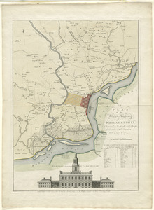
A plan of the city and environs of Philadelphia
1833.
A Plan of West Florida, the Isle of Orleans, and some parts of the Spanish dominions to the westward of the Mississipi
1834.
Plano del Pto. de la Movila situado en la latd. N. de 30⁰ 10ʹ tomado á los Ings., el día 14 de marzo de 1780
1835.
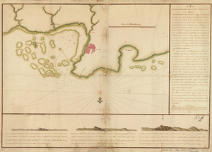
Plano del puerto del Guárico, cuyo conocimto. y entrada es del modo siguiente
1836.
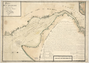
Baye de la Delaware avec les ports, sondes, dangers, bancs, &c. depuis les caps jusqu'a Philadelphie : d'après la carte de...
1837.
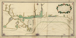
Carte de la coste de la province de la Louisiane et des bouches du Micissipy ou fleuve St. Louis
1838.
Pansacola o Santta María de Galbe, puerto y presidio del Ry. de España situado en la costa del nortte del Seno Mexicano, los...
1839.
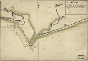
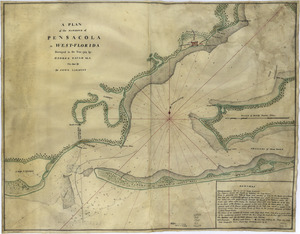
A plan of the harbour of Pensacola in West-Florida
1840.
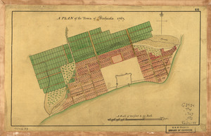
A Plan of the town of Pensacola, 1767
‹ Prev
Next ›
1
2
…
88
89
90
91
92
93
94
95
96
…
547
548