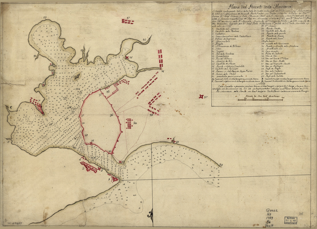
Plano del puerto de la Havana, situado en la parte del N. de la ysla de Cuba en la lattd. de 23⁰10ʹ y en longd. astronómica de 293⁰47ʹ, meridiano de Tenerife ... el año de 1783 por Dn. Josef de Sn. Martin, the. de Navio de la Rl. Armada
This map is also available in American Revolutionary Geographies Online (ARGO), a collections portal especially built for material relating to the American Revolutionary War Era. Visit ARGO to learn more about this item and explore the historical geography of North America in the late eighteenth century.
Item Information
- Title:
- Plano del puerto de la Havana, situado en la parte del N. de la ysla de Cuba en la lattd. de 23⁰10ʹ y en longd. astronómica de 293⁰47ʹ, meridiano de Tenerife ... el año de 1783 por Dn. Josef de Sn. Martin, the. de Navio de la Rl. Armada
- Creator:
- Boto Villa, Josef
- Name on Item:
-
Copiado por Dn. Josef Boto Villa, Señor 2o piloto del No. de la Armada en este año de 1790
- Date:
-
[1790]
- Format:
-
Maps/Atlases
Manuscripts
- Location:
- Library of Congress Geography and Map Division
- Collection (local):
-
Library of Congress Collection
- Subjects:
-
Havana Bay (Cuba)--Maps--Early works to 1800
Coasts--Cuba--Havana Bay--Maps--Early works to 1800
- Places:
-
Havana (province)Havana
- Extent:
- 1 manuscript map : hand color 45 x 62 cm.
- Terms of Use:
-
No known copyright restrictions.
This work is licensed for use under a Creative Commons Attribution Non-Commercial Share Alike License (CC BY-NC-SA).

- Scale:
-
Scale ca. 1:16,000
- Language:
-
Spanish
- Catalog Record:
-
https://lccn.loc.gov/74690699
- Notes:
-
Manuscript, pen-and-ink and red and yellow watercolors.
Watermark: Beehive.
Depths shown by soundings.
Oriented with north to the bottom.
Mounted on cloth backing.
Indexed.
Maggs number annotated in pencil in lower right corner: 105.
- Notes (date):
-
This date is inferred.
- Notes (citation):
-
LC Maps of North America, 1750-1789, 1820
LC Luso-Hispanic World, 353
- Identifier:
-
ar182000