Toggle navigation
LMEC Home
Exhibitions
Georeferencing
Tools for Teachers
Collections
My Favorites
Sign Up / Log In
Search
Search the map portal
Map Collection
Map Collection
Map Sets
Search
Search
Search for
Search In
All Fields
Creator
Title
Subject
Place
Search All Digital Collections
Advanced Search
10836 Results
My Search
Start Over
All Fields
americas
Remove constraint All Fields: americas
Filter your Search
Place
North and Central America
10,232
United States
8,361
Massachusetts
2,778
Suffolk (county)
1,673
Boston
1,629
Canada
936
New York
640
Middlesex (county)
438
more
Place
»
Topic
Boston (Mass.)--Maps
745
City planning--Massachusetts--Boston--Maps
418
United States--History--Revolution, 1775-1783--Maps
327
United States--Maps
319
Real property--Massachusetts--Boston--Maps
254
Urban renewal--Massachusetts--Boston--Maps
254
Massachusetts--Maps
230
Insurance surveys
194
more
Topic
»
Date
Date range begin
–
Date range end
Current results range from
1507
to
2023
View distribution
Creator
Boston Redevelopment Authority
404
United States. Hydrographic Office
365
Des Barres, Joseph F. W. (Joseph Frederick Wallet), 1722-1824
197
Jefferys, Thomas, -1771
150
George, III, King of Great Britain, 1738-1820
146
O.H. Bailey & Co
146
George, IV, King of Great Britain, 1762-1830
145
Royal United Services Institute for Defence and Security Studies
139
more
Creator
»
Format
Maps/Atlases
10,713
Manuscripts
916
Prints
60
Books
43
Drawings/Illustrations
43
Photographs
15
Objects/Artifacts
7
Posters
3
more
Format
»
Georeferenced
Yes
823
No
10,013
Collection
Norman B. Leventhal Map & Education Center Collection
6,600
American Revolutionary War-Era Maps
3,123
Boston and New England Maps
2,897
Urban Maps
2,277
William L. Clements Library Collection
892
Maritime Charts and Atlases
814
Library of Congress Collection
552
Boston Redevelopment Authority Collection
475
more
Collection
»
Available to use
No known restrictions
7,653
Creative Commons license
1,540
Search Constraints
Sort by relevance
relevance
title
date (asc)
date (desc)
Number of results to display per page
20 per page
10
per page
20
per page
50
per page
100
per page
View results as:
grid view
map view
Search Results
10641.
Petersburg and Five Forks
10642.
Plan du detroit de Belle Isle et du Golphe St. Laurent pour la coste du nord
10643.
Plan of ground about Wilmington
10644.
A plan of Manchac 1774
10645.
Plan of Mount Hope Cemetery : including the City Cemetery belonging to the City of Boston and situated in West Roxbury &...
10646.
A plan of New York Island, with part of Long Island, Staten Island, & East New York : with a particular description of the...
10647.
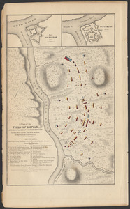
A plan of the field of battle and disposition of the troops as they were on the march at the time of the attack, July 9th, 1755
10648.
A plan of the river Ohio from Fort Pitt to the Mississipi : by order of ye chief engineer
10649.
Plan of Thompson Pond Settlement between Raymondtown and Poland, made by David Purington, dated January 5, 1796.
10650.
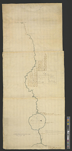
Plano del puerto de Gaston situado en la latitude N de 53 [degrees] 28' longd 24 [degrees] 21 al o de S. Blas descubierto este ano
10651.
The Price & Lee Co's new map of Caldwell, Verona, Essex Fells, Cedar Grove, Essex County, New Jersey
10652.
Rand McNally & Co.'s map of New York City, Brooklyn, Jersey City and vicinity
10653.
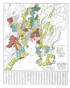
Residential security map of New Haven, East Haven, West Haven, North Haven and Hamden, Conn.
10654.
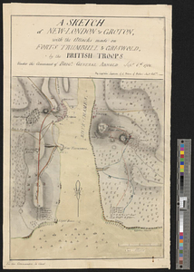
A sketch of New-London or Groton, with the attacks made on Forts Trumbull & Griswold by the British troops under the command of...
10655.
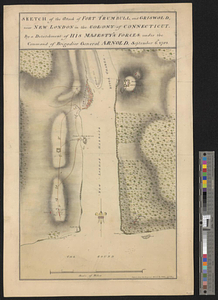
Sketch of the attack of Fort Trumbull, and Griswold, near New London in the colony of Connecticut, by a detachment of his...
10656.
A sketch of the entrance from the sea to Apalachy and part of the environs
10657.
A survey of the passage to the river Missisippi by the Lakes Pontchartrain and Maurepas and the river Iberville : 10th January...
10658.
A true coppy from an ancient plan of E. Hutchinson's, Esqr. & from Jose. Heath in 1719 & Phins. Jones's survey in 1731 & from...
10659.
Various plans and draughts of cities, towns, harbours &c
10660.
West Indies, harbors on Dominica Island : republished from the Brt. Admty. chart of June 1873
‹ Prev
Next ›
1
2
…
529
530
531
532
533
534
535
536
537
…
541
542


![Plano del puerto de Gaston situado en la latitude N de 53 [degrees] 28' longd 24 [degrees] 21 al o de S. Blas descubierto este ano](https://bpldcassets.blob.core.windows.net/derivatives/metadata/commonwealth-oai:c534kn51x/image_thumbnail_300.jpg)