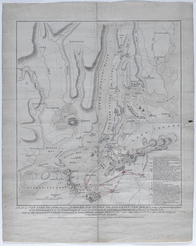
A plan of New York Island, with part of Long Island, Staten Island, & East New York : with a particular description of the engagement on the Woody Heights of Long Island, between Flatbush and Brooklyn, on the 27th of August 1776, between His Majesty's forces commanded by General Howe and the Americans under Major General Putnam, with the subsequent disposition of both armies
Item Information
- Title:
- A plan of New York Island, with part of Long Island, Staten Island, & East New York : with a particular description of the engagement on the Woody Heights of Long Island, between Flatbush and Brooklyn, on the 27th of August 1776, between His Majesty's forces commanded by General Howe and the Americans under Major General Putnam, with the subsequent disposition of both armies
- Cartographer:
- Faden, William, 1749-1836
- Name on Item:
-
by Wm. Faden
- Date:
-
1776
- Format:
-
Maps/Atlases
- Location:
-
Phillips Academy
Archives and Special Collections - Collection (local):
-
Robert E. Diefenbach Map Collection
- Places:
-
New YorkRichmond (county)Staten Island (island)
New YorkNew York (county)Manhattan Island (island)
New YorkLong Island (island)
- Extent:
- 1 map ; 51 x 43 cm
- Terms of Use:
-
We believe that this item has no known US copyright restrictions. Though not required, if you want to credit us as the source, please use the following statement, "From The Trustees of Phillips Academy." Doing so helps us track how our collection is used and helps justify freely releasing even more content in the future.
This work is in the public domain under a Creative Commons No Rights Reserved License (CC0).
- Scale:
-
Scale ca. 1:84,000
- Language:
-
English
- Notes:
-
Title from item or accompanying material.
- Notes (date):
-
Date from item or accompanying material.
- Identifier:
-
21_219_F_9
 IIIF Manifest