Toggle navigation
LMEC Home
Exhibitions
Georeferencing
Tools for Teachers
Collections
My Favorites
Sign Up / Log In
Search
Search the map portal
Map Collection
Map Collection
Map Sets
Search
Search
Search for
Search In
All Fields
Creator
Title
Subject
Place
Search All Digital Collections
Advanced Search
4128 Results
My Search
Start Over
Date Range
before 1800
Remove constraint Date Range: before 1800
All Fields
americas
Remove constraint All Fields: americas
Filter your Search
Place
North and Central America
3,718
United States
2,492
Canada
642
Massachusetts
471
New York
376
North America
307
South America
204
Maine
203
more
Place
»
Topic
United States--History--Revolution, 1775-1783--Maps
321
North America--Maps--Early works to 1800
179
United States--History--French and Indian War, 1754-1763--Maps
161
Manuscript maps--Early works to 1800
121
New England--Maps--Early works to 1800
89
America--Maps--Early works to 1800
73
United States--Maps--Early works to 1800
59
Western Hemisphere--Maps--Early works to 1800
59
more
Topic
»
Date
Date range begin
–
Date range end
Current results range from
1507
to
1899
View distribution
Creator
Des Barres, Joseph F. W. (Joseph Frederick Wallet), 1722-1824
196
Jefferys, Thomas, -1771
149
George, III, King of Great Britain, 1738-1820
146
George, IV, King of Great Britain, 1762-1830
145
Royal United Services Institute for Defence and Security Studies
137
Amherst, Jeffery Amherst, Baron, 1717-1797
110
Sayer, Robert, 1725-1794
99
Faden, William, 1749-1836
93
more
Creator
»
Format
Maps/Atlases
4,046
Manuscripts
739
Drawings/Illustrations
36
Prints
34
Books
8
Objects/Artifacts
3
Documents
1
Ephemera
1
Georeferenced
Yes
113
No
4,015
Collection
American Revolutionary War-Era Maps
3,095
Norman B. Leventhal Map & Education Center Collection
1,166
William L. Clements Library Collection
887
Library of Congress Collection
552
Town plans, 1794
401
British Library Collection
346
Maritime Charts and Atlases
331
Richard H. Brown Revolutionary War Map Collection at Mount Vernon
274
more
Collection
»
Available to use
No known restrictions
1,525
Creative Commons license
1,430
Search Constraints
Sort by relevance
relevance
title
date (asc)
date (desc)
Number of results to display per page
20 per page
10
per page
20
per page
50
per page
100
per page
View results as:
grid view
map view
Search Results
4061.
Freti Magellanici ac novi freti vulgo le Maire
4062.
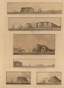
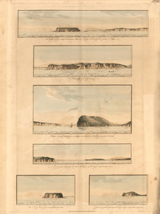
The isle Haut ...; and Cape Chignecto ... ; The western cliffs of Cape Dore ; A view of Cape Baptist in the entrance into the...
4063.
The isle Haut ...; and Cape Chignecto ... ; The western cliffs of Cape Dore ; A view of Cape Baptist in the entrance into the...
4064.
A large draught of New England, New York and Long Island
4065.
A Map of New England & ye country adjacent, : extending northward to Quebec, & westward to Niagara, on Lake Ontario; shewing...
4066.
A map of the Delaware and Chesapeak bays with the peninsula between them
4067.
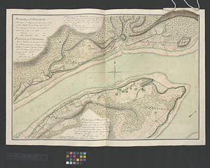
Parish of St. Joachim. Parish of St. Famille. Parish of St. Anne. Parish of St. François
4068.
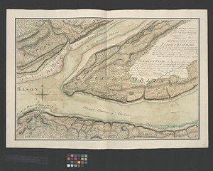
Parish of St. Lawrence. Parish of Beaumont. Parish of St. Peter
4069.
Part of the modern counties of Union, Middlesex, and Somerset, New Jersey and Staten Island, New York
4070.
Part of the modern counties of Union, Middlesex, and Somerset, New Jersey and Staten Island, New York
4071.
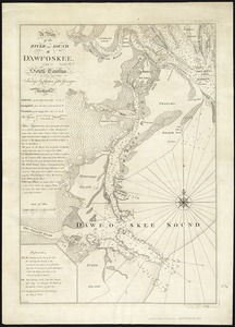
A plan of the river and sound of D'Awfoskee in South Carolina
4072.
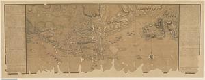
A plan of the settled part of Canada reduced from the large survey made in the years 1760 & 1761 by order of General Murray...
4073.
Plan of the siege of Louisbourg in 1758, carry'd on by the British army commanded by His Excellency Major General Amherst, and...
4074.
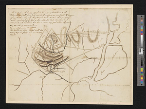
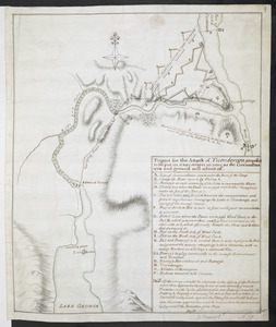
Project for the Attack of Ticonderoga, proposed to be put in executino as near as the circumstances and ground will admit of
4075.
Ruatan or Rattan
4076.
Carte Du Lac ontario nouvellement Rellevé avec ces port a grand pois a bitté Lescadre Engloisse & francoisse Leur gremant...
4077.
Chart of Passamaquoddy Bay and Grand Manan Island, New Brunswick
4078.
A chart of the sea coast of New Foundland, New Scotland, New England, New York, New Jersey, with Virginia and Maryland
4079.
Fort Edward to Ticonderoga
4080.
Plan de la rivière du Cap Fear depuis la barre jusques à Brunswick
‹ Prev
Next ›
1
2
…
200
201
202
203
204
205
206
207