Toggle navigation
LMEC Home
Exhibitions
Georeferencing
Tools for Teachers
Collections
My Favorites
Sign Up / Log In
Search
Search the map portal
Map Collection
Map Collection
Map Sets
Search
Search
Search for
Search In
All Fields
Creator
Title
Subject
Place
Search All Digital Collections
Advanced Search
25 Results
My Search
Start Over
medford massachusetts
Remove constraint medford massachusetts
Filter your Search
Place
North and Central America
24
United States
23
Middlesex (county)
16
Medford
11
Boston
9
Massachusetts
9
Suffolk (county)
9
Middlesex Fells
3
more
Place
»
Topic
Medford (Mass.)--Maps
8
Real property--Massachusetts--Medford--Maps
5
Boston (Mass.)--Buildings, structures, etc--Maps--Early works to 1800
3
Boston (Mass.)--History--Revolution, 1775-1783--Maps--Early works to 1800
3
Boston (Mass.)--Maps
3
Fortification--Massachusetts--Boston--Maps--Early works to 1800
3
Middlesex Fells Reservation (Mass.)--Maps
3
Belmont (Mass.)--Maps
2
more
Topic
»
Date
Date range begin
–
Date range end
Current results range from
1775
to
1990
View distribution
Creator
Pelham, Henry, 1749-1806
4
Geo. W. Stadly & Co.
3
Massachusetts. Metropolitan Park Commission
3
Jukes, Francis
2
Tufts, Peter
2
Allen, John S., 1946-
1
Baldwin, Loammi, 1780-1838
1
Boston (Mass.). Office of Chief Engineer
1
more
Creator
»
Format
Maps/Atlases
25
Manuscripts
1
Georeferenced
Yes
2
No
23
Collection
Norman B. Leventhal Map Center Collection
13
Boston and New England Maps
12
American Revolutionary War-Era Maps
9
Urban Maps
9
William L. Clements Library Collection
4
Massachusetts Real Estate Atlases
2
Richard H. Brown Revolutionary War Map Collection at Mount Vernon
2
David Judkins Weaver Papers
1
more
Collection
»
Available to use
No known restrictions
14
Creative Commons license
5
Search Constraints
Sort by relevance
relevance
title
date (asc)
date (desc)
Number of results to display per page
20 per page
10
per page
20
per page
50
per page
100
per page
View results as:
grid view
map view
Search Results
1.
Medford, Massachusetts : 1880
2.
West Medford, Massachusetts : 1897
3.
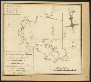
Map of the town of Medford, Middlesex County, Mass : surveyed by order of the town
4.
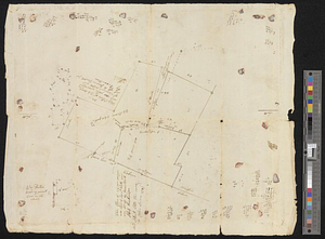
These plans represent the land of Capt Ebenezer Brook, late of Medford
5.
Plan of lots in Medford, formerly owned by Joseph B. Felt, and known as the John Quincy Adams Estate
6.
Atlas of the city of Medford, Middlesex County, Mass. ; Atlas of the town of Hyde Park, Norfolk County, Mass. ; Atlas of the...
7.
Plan of Medford made by John Sparrell, dated 1830
8.
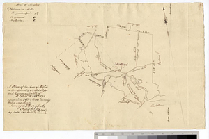
Plan of Medford made by Peter Tufts, Jr., dated 1794.
9.
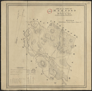
A plan of the town of Medford in the county of Middlesex and commonwealth of Massachusetts containing 5631 acres including...
10.
Saml Wath to Abel Richardson : Wm Foster to James Foster exec ditto
11.
Plan of Boston & Maine Railroad terminal division Boston, Cambridge, Somerville, Everett and Medford
12.
Atlas of Massachusetts
13.
Atlas of Middlesex County. Vol. 1. Cambridge, Somerville, Arlington, Belmont, Watertown, Everett, Malden, Medford, Newton,...
14.
Atlas of Middlesex County : volume 1, Cambridge, Somerville, Arlington, Belmont, Watertown, Everett, Malden, Medford, Newton,...
15.
Boston's bikemap : Arlington, Belmont, Brookline, Cambridge, Chelsea, Everett, Lexington, Malden, Medford, Needham, Newton,...
16.
A plan of Boston in New England with its environs, including Milton, Dorchester, Roxbury, Brooklin, Cambridge, Medford,...
17.
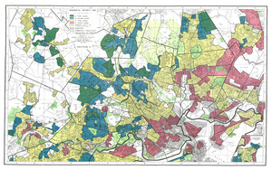
Residential security map of Boston, Mass.
18.
A plan of Boston in New England with its environs : including Milton, Dorchester, Roxbury, Brooklin, Cambridge, Medford,...
19.
A plan of Boston in New England with its environs : including Milton, Dorchester, Roxbury, Brooklin, Cambridge, Medford,...
20.
A plan of Boston in New England with its environs : including Milton, Dorchester, Roxbury, Brooklin, Cambridge, Medford,...
‹ Prev
Next ›
1
2