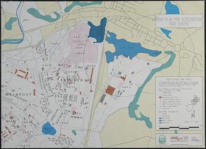
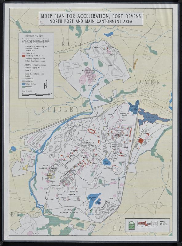
MDEP plan for acceleration, Fort Devens, north post and main cantonment area
Item Information
- Title:
- MDEP plan for acceleration, Fort Devens, north post and main cantonment area
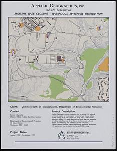
- Cartographer:
- Applied Geographics, Inc.
- Contributor:
- Massachusetts. Department of Environmental Protection
- Contributor:
- MassGIS (Office : Mass.)
- Contributor:
- Massachusetts. Executive Office of Environmental Affairs
- Name on Item:
-
map produced by Applied Geographics, Inc. ; Department of Environmental Protection ; Massachusetts Geographic Information System ; Massachusetts Executive Office of Environmental Affairs
- Date:
-
1992
- Format:
-
Maps/Atlases
- Location:
-
Boston Public Library
Norman B. Leventhal Map & Education Center - Collection (local):
-
Applied Geographics, Inc. Records
- Subjects:
-
Fort Devens (Mass.)--Maps
Environmental protection--Massachusetts--Fort Devens--Maps
Wellhead protection--Massachusetts--Fort Devens--Maps
- Places:
-
MassachusettsWorcester (county)Fort Devens
- Extent:
- 1 map : color, plastic-coated ; 56 x 40 cm
- Terms of Use:
-
No known copyright restrictions.
No known restrictions on use.
- Publisher:
-
Boston :
Applied Geographics, Inc.
- Scale:
-
Scale approximately 1:11,750
- Language:
-
English
- Notes:
-
Shows IRDMIS data, study areas, buildings with UST's, incident report spills, other compliance areas, MDEP's evaluation zones, public supply wells, and zone IIs.
Printed at a smaller size with actual scale smaller than given statement of 1" = 600'.
- Identifier:
-
06_01_018941
- Call #:
-
AppGeo Folder 4 no. 2
- Barcode:
-
30000008056778