Whale chart
Item Information
- Title:
- Whale chart
- Description:
-
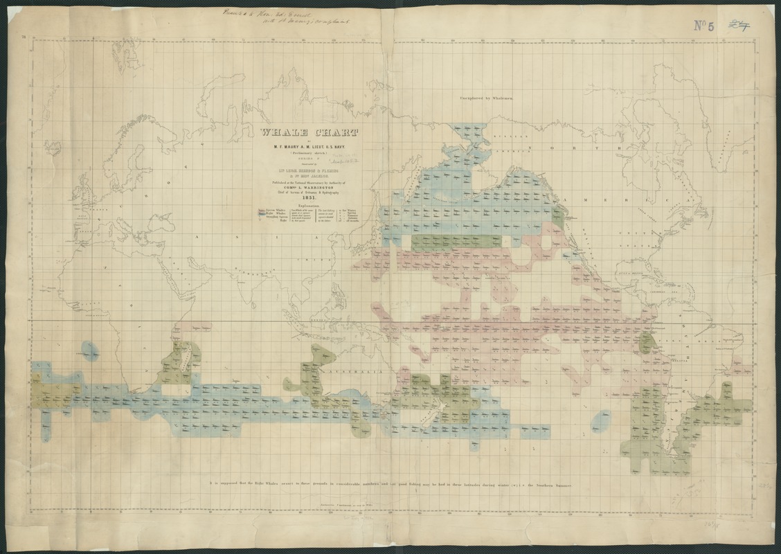
The importance of the mid-19th-century American whaling industry, which was dominated by ports in southern New England, especially New Bedford, Massachusetts, is documented by this innovative thematic map. It was prepared by Matthew Fontaine Maury, an American naval officer and oceanographer who served as the Superintendent of the U.S. Navy Depot of Charts and Instruments (later the U.S. Naval Observatory) from 1842 to 1861. Because of his contributions to oceanography including a series of wind and current charts for the world oceans, Maury is recognized as the father of the science of oceanography. Collecting data from various sources including logs from whaling ships, he compiled this map showing the distribution of several different species of whales, identifying each with a combination of color and pictorial symbols. For example, the occurrence of the sperm whale, which provided the basis of the New England whaling trade, was identified with a pink color and a small diagram of a whale with one spout. Seasonal variations were indicated by the letters w (winter), v (spring), s (summer), a (autumn), and all (all months). In constructing this map, Maury used a Mercator projection centered on the Pacific Ocean. While this projection was probably not the best choice for a single thematic topic, because it exaggerates the spatial extent of the southern and northern oceans, it was the commonly used projection for navigational purposes during the 19th century. By centering the map on the Pacific Ocean, however, Maury showed that the primary habitat of whales was the Pacific arena rather than the Atlantic, where the whale resources had been terribly depleted. Interestingly, the sperm whale distribution was heavily concentrated in the central Pacific. This includes the area between Hawaii and the California coast, appearing just to the right of the map's center, where New England whalers focused their efforts.
- Creator:
- Maury, Matthew Fontaine, 1806-1873
- Name on Item:
-
by M.F. Maury ; constructed by Lts. Leigh. Herndon & Fleming & Pd. Midn. Jackson.
- Date:
-
1851
- Format:
-
Maps/Atlases
- Location:
-
Boston Public Library
Norman B. Leventhal Map & Education Center - Collection (local):
-
Norman B. Leventhal Map & Education Center Collection
- Subjects:
-
Whales--Maps
Whaling--Maps
- Places:
-
World
- Extent:
- 1 map : col. ; 64 x 122 cm.
- Terms of Use:
-
No known copyright restrictions.
No known restrictions on use.
- Publisher:
-
Washington, D.C :
U.S. Navy, National Observatory
- Scale:
-
Scale not given.
- Language:
-
English
- Notes:
-
Preliminary sketch. Series F.
Exhibited in “Journeys of the Imagination,” at the Boston Public Library, Boston, MA, April - August 2006. MB (BRL)
- Notes (exhibitions):
-
Exhibited: "Crossing Boundaries: Art // Maps" organized by the Norman B. Leventhal Map & Education Center at the Boston Public Library, 2018-2019.
- Identifier:
-
05_01_000227
- Call #:
-
G9096.D4 1851 .M3
- Barcode:
-
39999052507082


