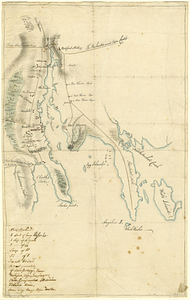
[Buildout analysis] New Bedford, Massachusetts
![[Buildout analysis] New Bedford, Massachusetts](https://bpldcassets.blob.core.windows.net/derivatives/images/commonwealth:v405z947d/image_access_800.jpg)
Item Information
- Title:
- [Buildout analysis] New Bedford, Massachusetts
- Cartographer:
- Applied Geographics, Inc.
- Contributor:
- Massachusetts. Executive Office of Environmental Affairs
- Contributor:
- MassGIS (Office : Mass.)
- Name on Item:
-
Executive Office of Environmental Affairs ; MassGIS ; produced by Applied Geographics, Inc.
- Date:
-
2000
- Format:
-
Maps/Atlases
- Location:
-
Boston Public Library
Norman B. Leventhal Map & Education Center - Collection (local):
-
Applied Geographics, Inc. Records
- Subjects:
-
New Bedford (Mass.)--Maps
Zoning--Massachusetts--New Bedford--Maps
Protected areas--Massachusetts--New Bedford--Maps
Real estate development--Massachusetts--New Bedford--Maps
- Places:
-
MassachusettsBristol (county)New Bedford
- Extent:
- 4 maps : color, plastic-coated ; 104 x 78 cm or smaller
- Terms of Use:
-
No known copyright restrictions.
No known restrictions on use.
- Publisher:
-
[Boston] :
Applied Geographics, Inc.
- Scale:
-
Scales differ
- Language:
-
English
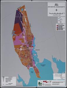
- Table of Contents:
-
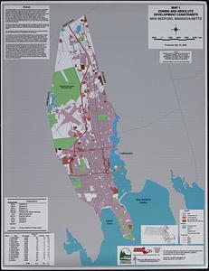
Map 1 Zoning and absolute development constraints
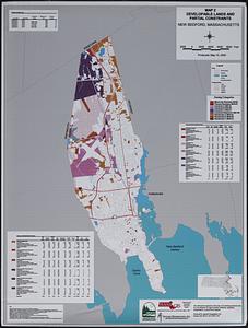
Map 2 Developable lands and partial constraints
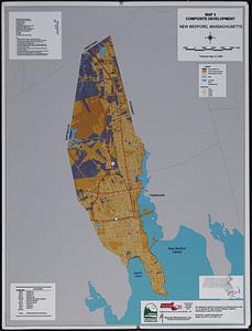
Map 3 Composite development
Map 4 Zoning.
- Notes:
-
"Produced: May 15, 2000."
Includes text and statistics.
- Identifier:
-
06_01_019001
- Call #:
-
AppGeo Folder 7 no. 4-7
- Barcode:
-
30000008057170