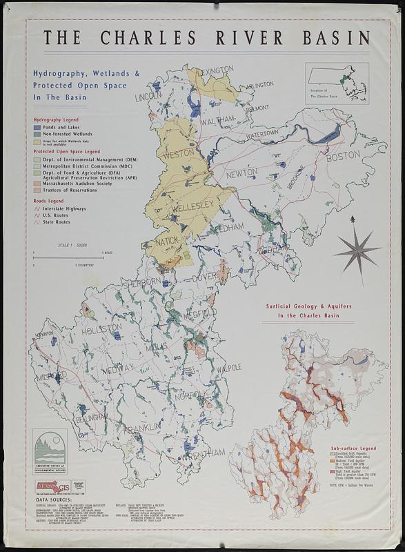
The Charles River basin : hydrography, wetlands & protected open space in the basin
Item Information
- Title:
- The Charles River basin : hydrography, wetlands & protected open space in the basin
- Cartographer:
- MassGIS (Office : Mass.)
- Contributor:
- Massachusetts. Executive Office of Environmental Affairs
- Name on Item:
-
MassGIS
- Date:
-
1988
- Format:
-
Maps/Atlases
- Location:
-
Boston Public Library
Norman B. Leventhal Map & Education Center - Collection (local):
-
Applied Geographics, Inc. Records
- Subjects:
-
Charles River Watershed (Mass.)--Maps
Hydrology--Massachusetts--Charles River Watershed--Maps
Aquifers--Massachusetts--Charles River Watershed--Maps
Wetlands--Massachusetts--Charles River Watershed--Maps
Protected areas--Massachusetts--Charles River Watershed--Maps
Open spaces--Massachusetts--Charles River Watershed--Maps
- Places:
-
MassachusettsCharles (river)
- Extent:
- 1 map : color ; 117 x 84 cm
- Terms of Use:
-
No known copyright restrictions.
No known restrictions on use.
- Scale:
-
Scale 1:50,000
- Language:
-
English
- Notes:
-
Inset: Surficial geology & aquifers in the Charles basin.
Includes location map.
- Identifier:
-
06_01_019074
- Call #:
-
AppGeo Folder 31 no. 14
- Barcode:
-
30000008064324