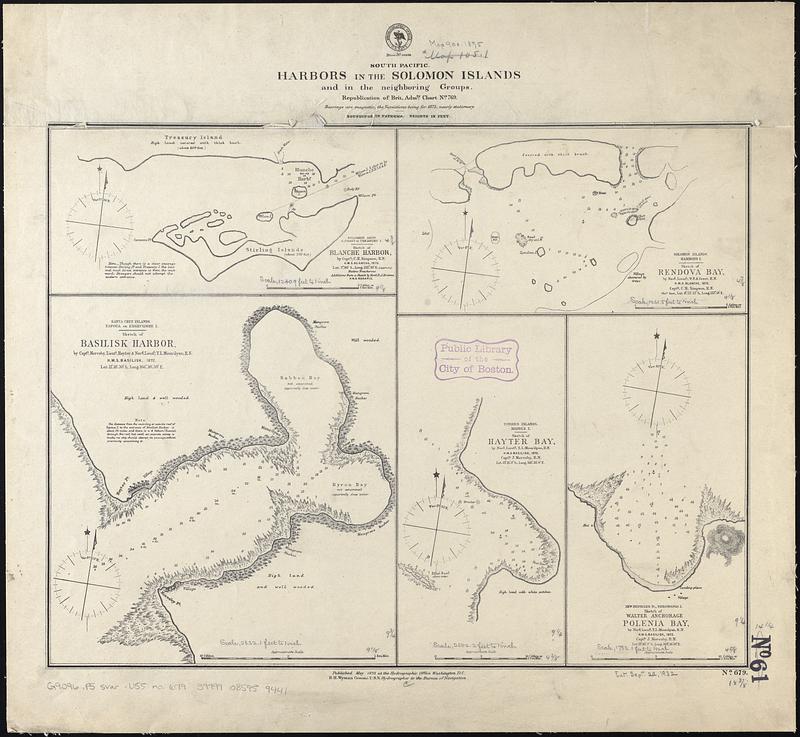
South Pacific, harbors in the Solomon Islands and in the neighboring groups : republication of Brit. Admty. chart no. 769
Item Information
- Title:
- South Pacific, harbors in the Solomon Islands and in the neighboring groups : republication of Brit. Admty. chart no. 769
- Title (alt.):
-
Harbors in the Solomon Islands and in the adjoining groups
- Issuing body:
- United States. Hydrographic Office
- Date:
-
1875
- Format:
-
Maps/Atlases
- Genre:
-
Nautical charts
- Location:
-
Boston Public Library
Norman B. Leventhal Map & Education Center - Collection (local):
-
Norman B. Leventhal Map & Education Center Collection
- Subjects:
-
Basilisk Harbor (Solomon Islands)--Maps
Rendova Harbor (Solomon Islands)--Maps
Blanche Harbor (Solomon Islands)--Maps
Lonakwarenga Bay (Vanuatu)--Maps
Polénia (Vanuatu)--Maps
Harbors--Solomon Islands--Maps
Harbors--Vanuatu--Maps
Nautical charts--Solomon Islands
Nautical charts--Vanuatu
- Places:
-
Solomon IslandsWestern (province)Rendova Island (island)
Basilisk Harbour
Blanche Harbour
Lonakwarenga Bay
Polénia
- Extent:
- 5 maps on 1 sheet ; 36 x 47 cm
- Terms of Use:
-
No known copyright restrictions.
No known restrictions on use.
- Publisher:
-
Washington, D.C. :
Hydrographic Office
- Scale:
-
Scales differ
- Language:
-
English
- Table of Contents:
-
Sketch of Blanche Harbor
Sketch of Rendova Bay
Sketch of Basilisk Harbor
Sketch of Hayter Bay
Sketch of Walter anchorage, Polenia Bay
- Notes:
-
Relief shown by hachures. Depths shown by soundings.
- Identifier:
-
06_01_017469
- Call #:
-
G9096.P5 svar .U55 no. 679
- Barcode:
-
39999085959441