South west Pacific, anchorages in the Solomon Islands : from various authorities with corrections to 1874 ; republication of British Admiralty chart no. 209
Item Information
- Title:
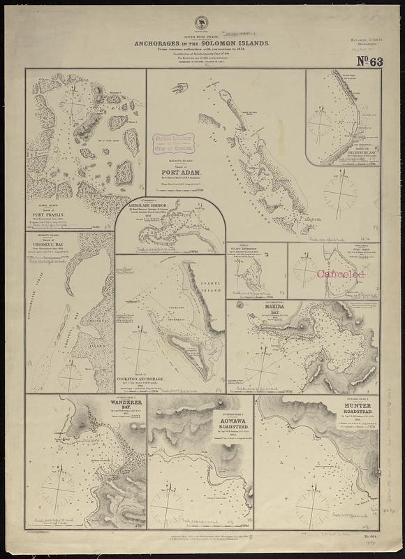
- South west Pacific, anchorages in the Solomon Islands : from various authorities with corrections to 1874 ; republication of British Admiralty chart no. 209
- Issuing body:
- United States. Hydrographic Office
- Date:
-
[1881]
- Format:
-
Maps/Atlases
- Genre:
-
Nautical charts
- Location:
-
Boston Public Library
Norman B. Leventhal Map & Education Center - Collection (local):
-
Norman B. Leventhal Map & Education Center Collection
- Subjects:
-
Solomon Islands--Maps
Port Praslin (Solomon Islands)--Maps
Port Adam (Solomon Islands)--Maps
Hada Bay (Solomon Islands)--Maps
Astrolabe Bay (Solomon Islands)--Maps
Choiseul Bay (Solomon Islands)--Maps
Cockatoo Anchorage (Solomon Islands)--Maps
Vulavu (Solomon Islands)--Maps
Port Mary (Solomon Islands)--Maps
Makira Harbour (Solomon Islands)--Maps
Wanderer Bay (Solomon Islands)--Maps
Aowawa Road (Solomon Islands)--Maps
Hunter Road (Solomon Islands)--Maps
Anchorage--Maps
Nautical charts--Solomon Islands
- Places:
-
Solomon IslandsMakira and Ulawa (province)Makira Harbour (harbor)
Port Praslin
Port Adam
Hada Bay
Astrolabe Bay
Choiseul Bay
Cockatoo Anchorage
Vulavu
Port Mary
Wanderer Bay
Aowawa Road
Hunter Road
- Extent:
- 12 maps on 1 sheet ; 62 x 48 cm
- Terms of Use:
-
No known copyright restrictions.
No known restrictions on use.
- Publisher:
-
Washington, D.C. :
Hydrographic Office
- Language:
-
English
- Notes:
-
Relief shown by hachures and spot heights. Depths shown by soundings.
"Cor. (IV.76)(50.VII.81)."
Stamped "canceled."
- Notes (date):
-
This date is inferred.
- Identifier:
-
06_01_017540
- Call #:
-
G9096.P5 svar .U55 no. 664
- Barcode:
-
39999085960522


