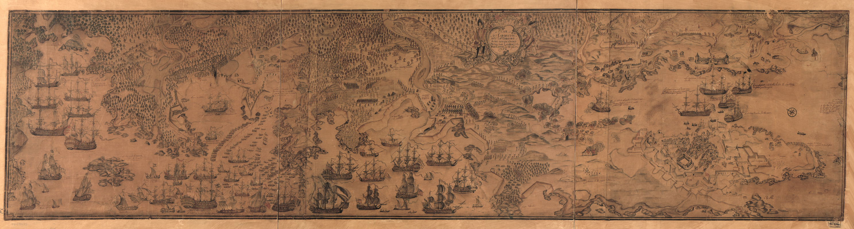
Plan du Cap Breton, dit Louisbovrg avec ces environs pries
This map is also available in American Revolutionary Geographies Online (ARGO), a collections portal especially built for material relating to the American Revolutionary War Era. Visit ARGO to learn more about this item and explore the historical geography of North America in the late eighteenth century.
Item Information
- Title:
- Plan du Cap Breton, dit Louisbovrg avec ces environs pries
- Title (alt.):
-
Plan du Cap Breton, dit Louisbourg avec ces environs pries
- Creator:
- Bockoune, Lamiralle
- Name on Item:
-
par Lamiralle Bockoune, le 26 jullet 1758
- Date:
-
[1758]
- Format:
-
Maps/Atlases
Manuscripts
- Location:
- Library of Congress Geography and Map Division
- Collection (local):
-
Library of Congress Collection
- Subjects:
-
Louisbourg (N.S.)--History--Siege, 1758--Maps, Manuscript--Early works to 1800
Louisbourg Region (N.S.)--Maps, Manuscript--Early works to 1800
Fortress of Louisbourg National Historic Site (N.S.)--Maps--Early works to 1800
- Places:
-
CanadaLouisbourg
- Extent:
- 1 map : hand col.; 51 x 203 cm.
- Terms of Use:
-
No known copyright restrictions.
This work is licensed for use under a Creative Commons Attribution Non-Commercial Share Alike License (CC BY-NC-SA).

- Scale:
-
Scale not given
- Language:
-
French
- Catalog Record:
-
https://lccn.loc.gov/74694645
- Notes:
-
Relief shown by shading and land forms.
Buildings, vegitation, ships and military troop and encampent positions shown pictorially.
Shows military troop and ship positions for the Siege of Louibourg in 1758.
Manuscript, pen-and-ink, pencil, and watercolor, covered with silk fabric and varnished.
Oriented with north toward the upper left.
- Notes (date):
-
This date is inferred.
- Identifier:
-
ar303100z

![[Plan de Louisburgh, et partie de la baye de Gabarus]](https://bpldcassets.blob.core.windows.net/derivatives/images/commonwealth:hx11z045s/image_thumbnail_300.jpg)


