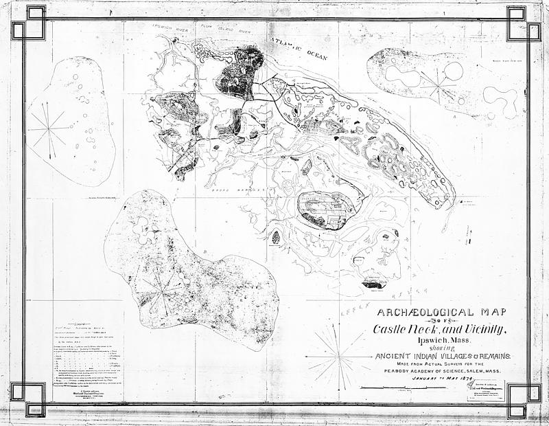
Archaeological map of Castle Neck and vicinity, Ipswich, Mass. showing ancient Indian villages & remains : made from actual surveys for the Peabody Academy of Science, Salem, Mass. : January to May 1874
Item Information
- Title:
- Archaeological map of Castle Neck and vicinity, Ipswich, Mass. showing ancient Indian villages & remains : made from actual surveys for the Peabody Academy of Science, Salem, Mass. : January to May 1874
- Cartographer:
- LeBaron, John Francis, 1865-1935
- Contributor:
- Brown, E. L.
- Name on Item:
-
J. Francis LeBaron
- Date:
-
1874
- Format:
-
Maps/Atlases
- Location:
-
Boston Public Library
Norman B. Leventhal Map & Education Center - Collection (local):
-
Norman B. Leventhal Map & Education Center Collection
- Subjects:
-
Castle Hill (Ipswich, Mass.)--Maps
Algonquian Indians--Massachusetts--Ipswich--Antiquities--Maps
- Places:
-
MassachusettsEssex (county)Ipswich
Castle Hill
- Extent:
- 1 online resource (1 map)
- Terms of Use:
-
Reproduction from Thomas G. Beddall, imagery courtesy of the Norman B. Leventhal Map & Education Center at the Boston Public Library.
This work is licensed for use under a Creative Commons Attribution License (CC BY).

- Publisher:
-
Boston :
J. Francis LeBaron
- Language:
-
English
- Notes:
-
Scan of a photocopy made by Thomas G. Beddall, of a photocopy formerly in possession of the Trustees, itself likely photocopied from the original held by the Peabody Essex Museum.
Indicates shell heaps and indistinct remains.
Legend includes details of remains and discoverers of some sites.
Includes 3 insets.
- Identifier:
-
lebaron-castle-neck

![Ipswich and Annisquam harbors, Massachusetts [archaeology in 1874]](https://bpldcassets.blob.core.windows.net/derivatives/images/commonwealth:2f75vg12c/image_thumbnail_300.jpg)


