McConnell Park Dorchester : site plan
Item Information
- Title:
- McConnell Park Dorchester : site plan
- Cartographer:
- Schoenfeld Associates
- Cartographer:
- Boston (Mass.). Parks and Recreation Department
- Name on Item:
-
Schoenfeld Associates, Inc consulting engineers ; City of Boston Parks and Recreation Department
- Date:
-
September 1, 1971
- Format:
-
Maps/Atlases
- Location:
-
Boston Public Library
Central Library in Copley Square - Collection (local):
-
Boston Public Library Collection
- Subjects:
-
Dorchester (Boston, Mass.)--Maps
Parks--Massachusetts--Boston--Maps
McConnell Park (Boston, Mass.)--Maps
Site plans
Storm sewers--Massachusetts--Boston--Maps
Manholes--Massachusetts--Boston--Maps
Trees--Massachusetts--Boston--Maps
Underground utility lines--Massachusetts--Boston--Maps
City planning--Massachusetts--Boston--Maps
- Places:
-
MassachusettsSuffolk (county)BostonDorchester
- Extent:
- 1 map ; 74 x 103 cm
- Terms of Use:
-
No known copyright restrictions.
No known restrictions on use.
- Place of origin:
-
Boston, Mass.
- Language:
-
English
- Catalog Record:
-
Accompanying text
- Notes:
-
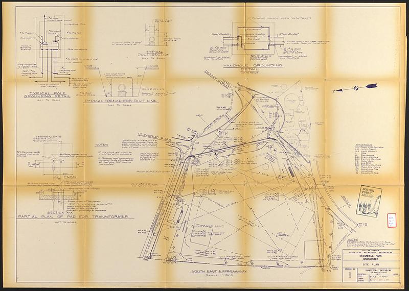
Accompanies a report on the design, construction supervision, and construction of a baseball diamond at McConnell Park.
Shows fencing, utilities, trees, poles and other park features.
Oriented with north to the left.
Relief shown by spot heights.
Includes 6 illustrations and notes.
- Identifier:
-
06_01_017357b
- Call #:
-
BRA/165 map E
- Barcode:
-
39999063522377


