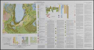
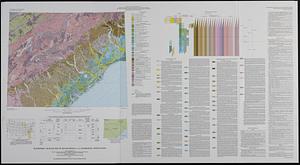
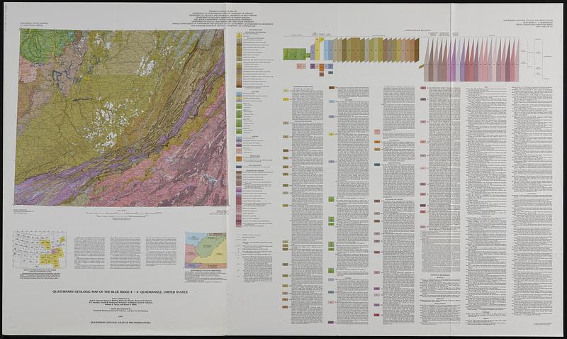
Quaternary geologic map of the Blue Ridge 4° x 6° quadrangle, United States
Item Information
- Title:
- Quaternary geologic map of the Blue Ridge 4° x 6° quadrangle, United States
- Publisher:
- Geological Survey (U.S.)
- Cartographer:
- Howard, Alan D.
- Cartographer:
- Richmond, Gerald Martin, 1914-
- Cartographer:
- Fullerton, David S.
- Cartographer:
- Christiansen, Ann Coe
- Contributor:
- University of Virginia. Department of Environmental Sciences
- Name on Item:
-
Department of the Interior, U.S. Geological Survey ; state compilations by Alan D. Howard ... [et al.] ; edited and integrated by Gerald M. Richmond, David S. Fullerton and Ann Coe Christiansen ; prepared in cooperation with the Department of Environmental Science, University of Virginia ... [et al.]
- Date:
-
1991
- Format:
-
Maps/Atlases
- Location:
-
Boston Public Library
Norman B. Leventhal Map & Education Center - Collection (local):
-
Applied Geographics, Inc. Records
- Subjects:
-
Geology, Stratigraphic--Quaternary--Maps
Geology--Blue Ridge Mountains--Maps
- Places:
-
Blue Ridge (mountain)
- Extent:
- 1 map : col. ; 44 x 54 cm., on sheet 84 x 141 cm., folded in envelope 30 x 24 cm.
- Terms of Use:
-
No known copyright restrictions.
No known restrictions on use.
- Publisher:
-
Reston, Va. ; Denver, CO :
The Survey ; For sale by Map Distribution
- Scale:
-
Scale 1:1,000,000
- Projection:
- Lambert conformal conic proj.
- Language:
-
English
- Notes:
-
Relief shown by contours and spot heights.
"Compiled in 1979-83 and 1987."
Includes text, bibliography, and 2 ancillary maps: index map and responsibility for state compilations.
- Identifier:
-
06_01_019108
- Call #:
-
AppGeo Folder 35 no.4
- Barcode:
-
37777009356734