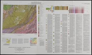
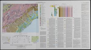
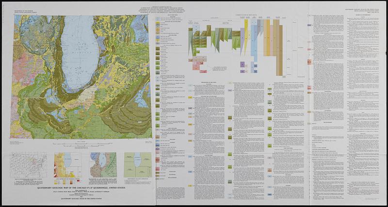
Quaternary geologic map of the Chicago 4° x 6° quadrangle, United States
Item Information
- Title:
- Quaternary geologic map of the Chicago 4° x 6° quadrangle, United States
- Title (alt.):
-
Quaternary geology, Chicago 4° x 6° quad., U.S.
- Cartographer:
- Lineback, Jerry A. (Jerry Alvin)
- Cartographer:
- Richmond, Gerald Martin, 1914-
- Cartographer:
- Fullerton, David S.
- Publisher:
- Geological Survey (U.S.)
- Contributor:
- Illinois State Geological Survey
- Name on Item:
-
state compilations by Jerry A. Lineback [and four others] ; Department of the Interior, United States Geological Survey ; edited and integrated by Gerald M. Richmond and David S. Fullerton
- Date:
-
1983
- Format:
-
Maps/Atlases
- Location:
-
Boston Public Library
Norman B. Leventhal Map & Education Center - Collection (local):
-
Applied Geographics, Inc. Records
- Subjects:
-
Geology, Stratigraphic--Quaternary--Maps
Geology--Lake States--Maps
- Places:
-
Wisconsin
Illinois
Indiana
Michigan
- Extent:
- 1 map : color ; 44 x 51 cm, on sheet 74 x 139 cm
- Terms of Use:
-
No known copyright restrictions.
No known restrictions on use.
- Publisher:
-
Reston, Va. :
U.S. Geological Survey
- Scale:
-
Scale 1:1,000,000
- Projection:
- Lambert conformal conic projection
- Language:
-
English
- Notes:
-
Relief shown by contours and spot heights. Depths shown by isolines and soundings.
Title on envelope: Quaternary geology, Chicago 4° x 6° quad., U.S.
"Prepared in cooperation with the Illinois State Geological Survey [and others]."
"Compiled in 1978-1980."
Includes text, ancillary maps, "Correlation of map units."
Covers parts of Illinois, Indiana, Michigan, Ohio and Wisconsin.
- Identifier:
-
06_01_019107
- Call #:
-
AppGeo Folder 35 no.3