Chicago
Item Information
- Title:
- Chicago
- Description:
-
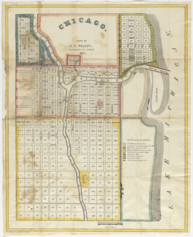
America Transformed: The founding of Chicago as a transportation, commercial, and industrial hub started in the 1830s, although the area was home to earlier Native, French and U.S. Army activities. The town was surveyed in 1830 and incorporated in 1833, with a population of 350. This 1834 map depicts the original configuration of the streets and blocks, which covered approximately 2.5 square miles. The site consisted of two entire sections and two partial sections in Township 39 North, Range 14 East, of the Third Principal Meridian. The map is color-coded to indicate the dates that various portions of the town were surveyed.
- Cartographer:
- Wright, John S. (John Stephen), 1815-1874
- Name on Item:
-
drawn by J.S. Wright, according to survey
- Date:
-
1834
- Format:
-
Maps/Atlases
- Location:
- Private Collection
- Collection (local):
-
Private Collection
- Subjects:
-
Chicago (Ill.)--Maps
Real property--Illinois--Chicago--Maps
- Places:
-
IllinoisCook (county)Chicago
- Extent:
- 1 manuscript map : hand color ; 46 x 37 cm
- Terms of Use:
-
No known copyright restrictions.
No known restrictions on use.
- Publisher:
-
New York :
P.A. Mesier's Lith. 28 Wall St.
- Scale:
-
Scale approximately 1:7,200
- Language:
-
English
- Notes:
-
Manuscript map in ink and watercolor.
Colored to indicate date surveyed.
- Notes (exhibitions):
-
Exhibited: "America transformed. Part 1: the United States expands westward," organized by the Norman B. Leventhal Map & Education Center at the Boston Public Library, 2019.
- Identifier:
-
06_01_016718