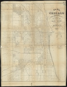
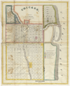
Insurance map of Chicago, 1868-9

Item Information
- Title:
- Insurance map of Chicago, 1868-9
- Cartographer:
- Sanborn, D. A. (Daniel Alfred), -1883
- Name on Item:
-
D.A. Sanborn, c.e.
- Date:
-
1869
- Format:
-
Maps/Atlases
- Location:
-
Boston Public Library
Norman B. Leventhal Map & Education Center - Collection (local):
-
Norman B. Leventhal Map & Education Center Collection
- Subjects:
-
Real property--Illinois--Chicago--Maps
Fire risk assessment--Illinois--Chicago--Maps
Chicago (Ill.)--Maps
- Places:
-
IllinoisCook (county)Chicago
- Extent:
- 1 atlas (30, that is 31, double leaves) : color maps ; 70 cm
- Terms of Use:
-
No known copyright restrictions.
No known restrictions on use.
- Publisher:
-
N.Y. :
D.A. Sanborn
- Scale:
-
Scale approximately 1:6,000
- Language:
-
English
- Notes:
-
Title taken from index map.
- Identifier:
-
06_01_016217 to 06_01_016247
- Call #:
-
G1409.C6G475 S26 1869
- Barcode:
-
39999065695718