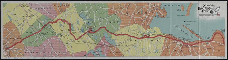
Map of the Brockton & Plymouth street railway
Item Information
- Title:
- Map of the Brockton & Plymouth street railway
- Title (alt.):
-
By trolley inland and alongshore to Plymouth : reached by the Brockton & Plymouth Street Railway Co. : illustrated guide and map
- Publisher:
- Geo. H. Walker & Co.
- Copyright holder:
- Stone & Webster
- Copyright holder:
- Little, Brown and Company
- Date:
-
1901
- Format:
-
Maps/Atlases
- Location:
-
Boston Public Library
Norman B. Leventhal Map & Education Center - Collection (local):
-
Norman B. Leventhal Map & Education Center Collection
- Subjects:
-
Plymouth (Mass.)--Maps
Plymouth (Mass.)--Description and travel
Street-railroads--Massachusetts--Plymouth--Maps
Street-railroads--Massachusetts--Kingston--Maps
Street-railroads--Massachusetts--Pembroke--Maps
Street-railroads--Massachusetts--Hanson--Maps
Street-railroads--Massachusetts--Whitman--Maps
Street-railroads--Massachusetts--Brockton--Maps
- Places:
-
MassachusettsPlymouth (county)Plymouth
- Extent:
- 1 map : color ; 14 x 57 cm + 1 booklet (27 pages ; 17 cm)
- Terms of Use:
-
No known copyright restrictions.
No known restrictions on use.
- Publisher:
-
Boston :
Geo. H. Walker & Co.
- Scale:
-
Scale approximately 1:71,000
- Language:
-
English
- Notes:
-
Oriented with north to the upper left.
Accompanied by: By trolley inland and alongshore to Plymouth, 1620 : reached by the Brockton & Plymouth Street Railway Co., (27 pages ; 17 cm).
- Identifier:
-
06_01_018553
- Call #:
-
G3764.P7P33 1901 .G46
- Barcode:
-
39999085968517


