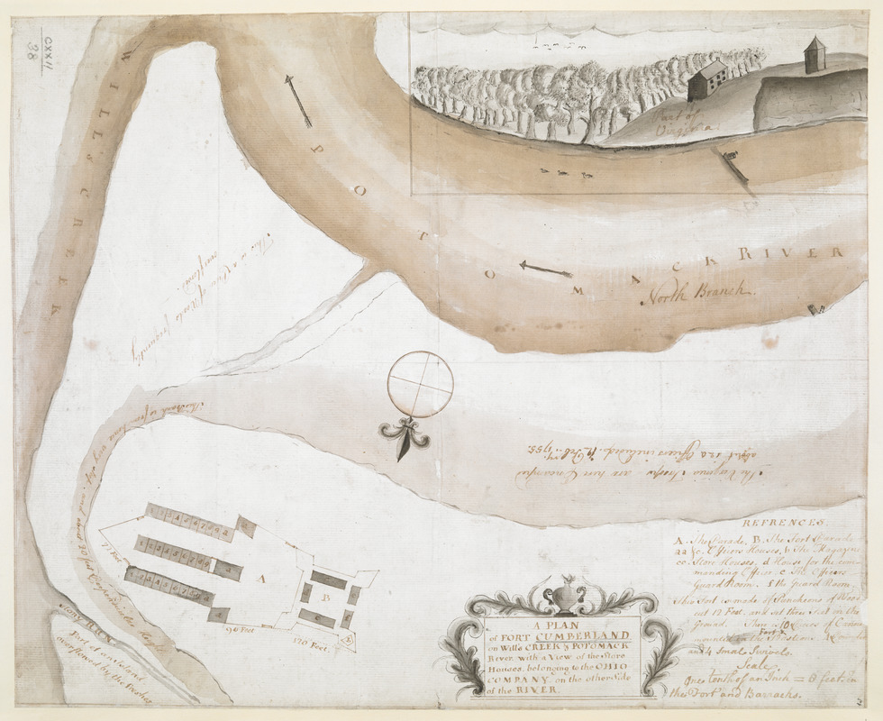
A PLAN of FORT CUMBERLAND on Will's CREEK & POTOMACK River with a View of the Store Houses belonging to the OHIO COMPANY on the Other Side of the River
This map is also available in American Revolutionary Geographies Online (ARGO), a collections portal especially built for material relating to the American Revolutionary War Era. Visit ARGO to learn more about this item and explore the historical geography of North America in the late eighteenth century.
Item Information
- Title:
- A PLAN of FORT CUMBERLAND on Will's CREEK & POTOMACK River with a View of the Store Houses belonging to the OHIO COMPANY on the Other Side of the River
- Former owner:
- George, III, King of Great Britain, 1738-1820
- Donor:
- George, IV, King of Great Britain, 1762-1830
- Contributor:
- Ohio Company (1747-1779)
- Date:
-
1755
- Format:
-
Maps/Atlases
Manuscripts
- Location:
- British Library
- Collection (local):
-
British Library Collection
- Subjects:
-
Military art and science--Cumberland (Md.)--Maps, Manuscript--Early works to 1800
Fort Cumberland (Cumberland, Md.)--Maps, Manuscript--Early works to 1800
Potomac River--Maps, manuscript--Early works to 1800
United States--History--French and Indian War, 1754-1763--Maps, Manuscript--Early works to 1800
- Places:
-
Potomac (river)
Allegany (county)Cumberland
- Extent:
- 1 map : manuscript pen and ink with watercolour ; 31 x 39 cm
- Terms of Use:
-
No known copyright restrictions.
This work is licensed for use under a Creative Commons Attribution Non-Commercial Share Alike License (CC BY-NC-SA).

- Scale:
-
Scale approximately 1:960
- Language:
-
English
- Catalog Record:
-
http://explore.bl.uk/BLVU1:LSCOP-ALL:BLL01004987636
- Notes:
-
Relief shown by shading.
North oriented to the bottom of the map, indicated by a central compass rose.
Title in a decorative cartouche at lower centre.
Includes a short lettered key and a brief description of the fort's construction at lower right.
Scale at lower right - "One tenth of an Inch = 8 feet in the Fort and Barracks".
A central note on the map reads "The Virginia Troops are here Encamped about 120 Officers included. 12 Feb.ry 1755".
The store houses of the Ohio Company on the opposite bank of the Potomac River (in Virginia) are depicted in profile.
Titled "A drawn Plan of Fort Cumberland on Will's Creek and Potomack River" in the Catalogue of Maps, Prints, Drawings, etc., forming the geographical and topographical collection attached to the Library of his late Majesty King George the third, etc., London, 1829.
Titled "A plan of Fort Cumberland, on Will's Creek and Potomack River, with a view of the store houses belonging to the Ohio Company on the other side of the river," and shewing where the Virginia troops were encamped, 12 Feb., 1755; drawn on a scale of 80 feet to an inch: 1 f. 3 in. x 12 1/2 in." in the Catalogue of the manuscript maps, charts, and plans, and of the topograhpical drawings in the British Museum.

![[A colored map of the route between Albany and Oswego; drawn about 1756, on a scale of 2 miles to an inch]](https://bpldcassets.blob.core.windows.net/derivatives/images/commonwealth:hx11z3223/image_thumbnail_300.jpg)
![[A map of Fort Carillon and environs]](https://bpldcassets.blob.core.windows.net/derivatives/images/commonwealth:hx11z538d/image_thumbnail_300.jpg)
![[A map of Fort Carillon and environs]](https://bpldcassets.blob.core.windows.net/derivatives/images/commonwealth:hx11z342k/image_thumbnail_300.jpg)
