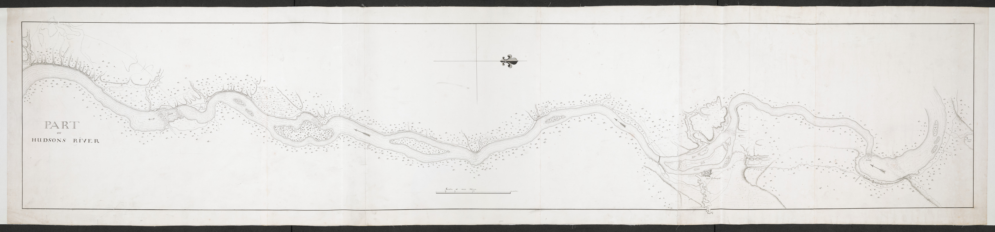
PART OF HUDSON'S RIVER
This map is also available in American Revolutionary Geographies Online (ARGO), a collections portal especially built for material relating to the American Revolutionary War Era. Visit ARGO to learn more about this item and explore the historical geography of North America in the late eighteenth century.
Item Information
- Title:
- PART OF HUDSON'S RIVER
- Former owner:
- Amherst, Jeffery Amherst, Baron, 1717-1797
- Former owner:
- Royal United Services Institute for Defence and Security Studies
- Date:
-
[1759]
- Format:
-
Maps/Atlases
- Location:
- British Library
- Collection (local):
-
British Library Collection
- Subjects:
-
Fortification--New York (State)--Fort Edward--Maps, Manuscript--Early works to 1800
Fort Edward (N.Y.)--Maps, Manuscript--Early works to 1800
Hudson River (N.Y. and N.J.)--Maps, Manuscript--Early works to 1800
- Places:
-
Hudson River
Washington (county)Fort Edward
- Extent:
- 1 map on 4 sheets : joined, manuscript pen and ink ; 33 x 171 cm
- Terms of Use:
-
No known copyright restrictions.
This work is licensed for use under a Creative Commons Attribution Non-Commercial Share Alike License (CC BY-NC-SA).

- Publisher:
-
[Place of production not identified] :
[producer not identified]
- Scale:
-
Scale approximately 1:12,000
- Language:
-
English
- Catalog Record:
-
http://searcharchives.bl.uk/IAMS_VU2:IAMS040-001999745
- Notes:
-
Date suggested as the Royal Blockhouse (built 1759), on the west bank of the Hudson River, opposite Fort Edward is not shown.
Relief is shown by shading.
Shows Fort Edward, Fort Miller and "M.r Beans Camp" (?).
Shows roads.
Shows title at lower left.
Shows scale bar at lower centre.
Consider Thomas Sowers as cartographer based on style?
Copy at Add Ms 57,713.2. In a solander box, R.U.S.I. Vol LXXV and LXXVIII. Comprises 4 sheets, joined and laid on linen. Green circular label to verso shows "11". White label to verso shows "DRAWER 28 SECTION 2". Blue label to verso shows "A 28/36". Pressmark stamped in black ink to verso.
- Notes (date):
-
9999
This date is inferred.