Winthrop/Boston Massachusetts : [coastal high hazard area base map]
Item Information
- Title:
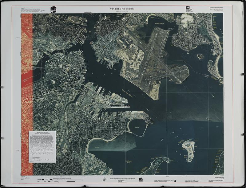
- Winthrop/Boston Massachusetts : [coastal high hazard area base map]
- Publisher:
- Massachusetts Coastal Zone Management Office
- Cartographer:
- Applied Geographics, Inc.
- Contributor:
- United States. Army. Corps of Engineers. New England District
- Name on Item:
-
map production and analysis by Applied Geographics, Inc. ; Massachusetts Coastal Zone Management
- Date:
-
[ca. 1995]
- Format:
-
Maps/Atlases
- Genre:
-
Remote-sensing maps
- Location:
-
Boston Public Library
Norman B. Leventhal Map & Education Center - Collection (local):
-
Applied Geographics, Inc. Records
- Subjects:
-
Boston (Mass.)--Remote-sensing images
Coast changes--Massachusetts--Boston--Remote-sensing images
Coast changes--Massachusetts--Boston--Maps
- Places:
-
MassachusettsSuffolk (county)Boston
- Extent:
- 1 remote-sensing image : color ; 80 x 100 cm, on sheet 92 x 120 cm
- Terms of Use:
-
No known copyright restrictions.
No known restrictions on use.
- Publisher:
-
[Boston] :
Massachusetts Coastal Zone Management
- Scale:
-
Scale 1:10,000
- Language:
-
English
- Notes:
-
Shows town boundaries, transects, transect numbers and shoreline change rate on a remote-sensing image.
Includes text about Massachusetts coastal high hazard area base maps for mitigation planning.
"Published for Commonwealth of Massachusetts, Executive Office of Environmental Affairs, Coastal Zone Management Office (CZM)."
"Published for and partial funding provided by Army Corps of Engineers, New England District."
"C-17."
- Identifier:
-
06_01_018904
- Call #:
-
AppGeo Folder 1 no. 18
- Barcode:
-
30000008056337