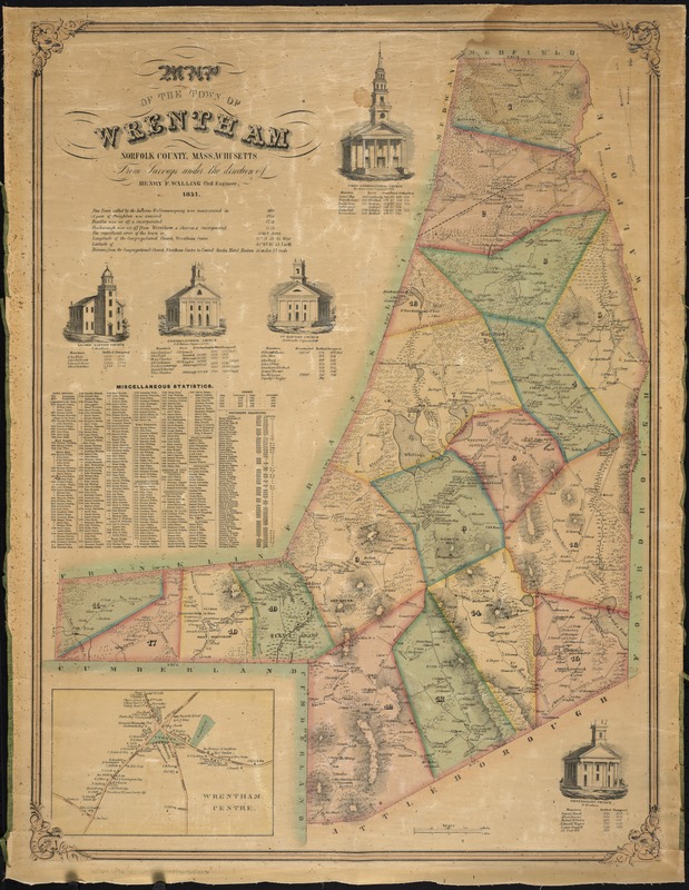
Map of the town of Wrentham : Norfolk County, Massachusetts
Item Information
- Title:
- Map of the town of Wrentham : Norfolk County, Massachusetts
- Creator:
- Walling, Henry Francis, 1825-1888
- Name on Item:
-
from surveys under the direction of W.F. Walling civil engineer.
- Date:
-
1851
- Format:
-
Maps/Atlases
- Location:
-
Boston Public Library
Norman B. Leventhal Map & Education Center - Collection (local):
-
Norman B. Leventhal Map & Education Center Collection
- Subjects:
-
Wrentham (Mass. : Town)--Maps
Norfolk County (Mass.)--Maps
- Places:
-
MassachusettsNorfolk (county)Wrentham
- Extent:
- 1 map : col. ; 78 x 58 cm.
- Terms of Use:
-
No known copyright restrictions.
No known restrictions on use.
- Publisher:
-
S.l :
[s.n.]
- Scale:
-
Scale [ca. 1:25,000]
- Language:
-
English
- Notes:
-
Shows county and town boundaries, names of surrounding towns and counties, names of streets, drainage, and other points of interest ; wards numbered.
Relief shown by hachures.
Inset: Wrentham Centre.
Includes "miscellaneous statistics."
Engravings include list of ministers: First Congregational Church -- Second Baptist Church -- Congregational Church -- 1st Baptist Church -- Universalist Church.
- Identifier:
-
06_01_008055
- Call #:
-
G3764.W96 1851 .W35
- Barcode:
-
39999065650101