Localities of one thousand cases of intestinal diseases (diarrhoea, cholera-infantum & dysentery) in children, for the months of July, August & Sept. 1863, 4 & 5
Item Information
- Title:
- Localities of one thousand cases of intestinal diseases (diarrhoea, cholera-infantum & dysentery) in children, for the months of July, August & Sept. 1863, 4 & 5
- Description:
-
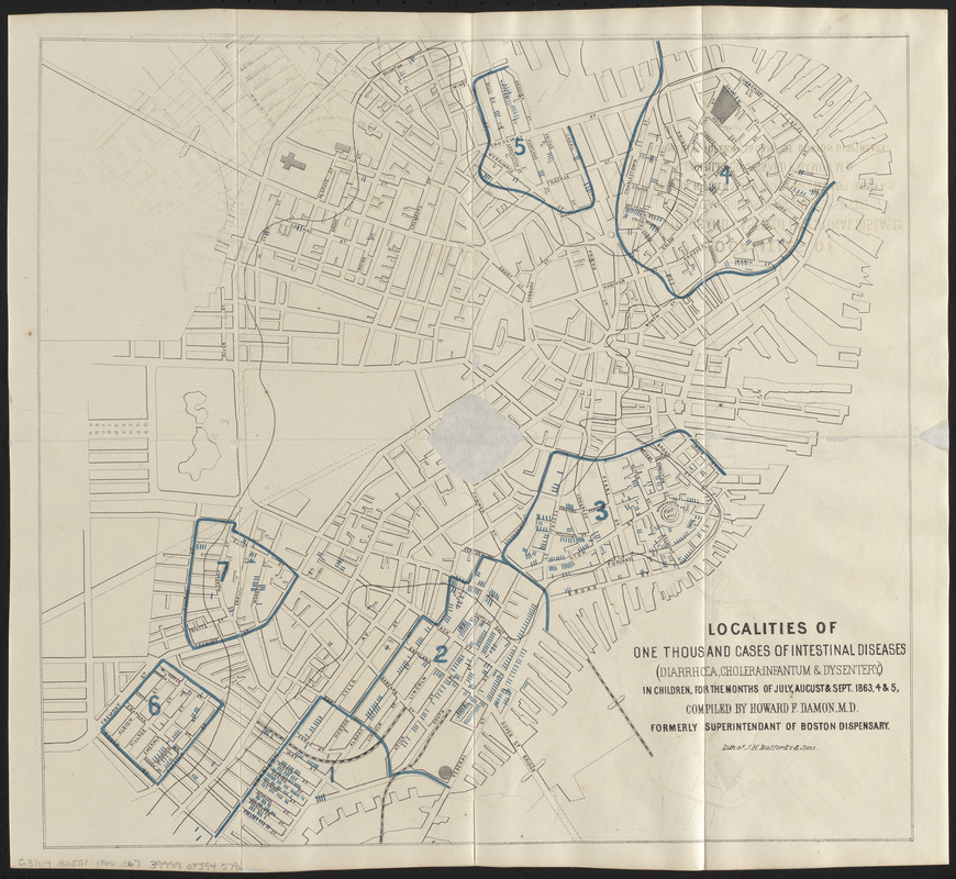
In 1854, following a series of debilitating cholera outbreaks in London, Dr. John Snow studied patterns of deaths, plotting their locations on a map overlaid with the city’s water districts. He concluded that a contaminated well dispensing a waterborne “cholera poison” was to blame for the outbreak. Following his lead, Boston’s physicians, including Dr. Howard Damon, mapped the spread of diseases in an effort to understand the connection between health and environment. Shown here, Damon’s map pinpoints individual cases within clearly delineated “unhealthy districts” in Boston; his accompanying report concluded that these outbreaks correlated directly with “overcrowding and imperfect drainage.”
- Cartographer:
- Boston (Mass.). City Physician's Office
- Lithographer:
- J.H. Bufford & Sons
- Contributor:
- Damon, Howard Franklin, 1833-1884
- Name on Item:
-
compiled by Howard F. Damon, M.D. formerly Superintendant of Boston Dispensary ; lith. of J.H. Bufford's & Sons
- Date:
-
[1866]
- Format:
-
Maps/Atlases
- Location:
-
Boston Public Library
Norman B. Leventhal Map & Education Center - Collection (local):
-
Norman B. Leventhal Map & Education Center Collection
- Subjects:
-
Diarrhea in children--Massachusetts--Boston--Maps
Cholera--Massachusetts--Boston--Maps
Dysentery--Massachusetts--Boston--Maps
Boston (Mass.)--Maps
- Places:
-
MassachusettsSuffolk (county)Boston
- Extent:
- 1 map ; 40 x 43 cm
- Terms of Use:
-
No known copyright restrictions.
No known restrictions on use.
- Publisher:
-
[Boston] :
[Publisher not identified]
- Scale:
-
Scale approximately 1:6,200
- Language:
-
English
- Notes:
-
Conservation of this piece was funded by an anonymous donor.
Oriented with north to the upper left.
From Communication from the City Physician on Asiatic cholera. City of Boston, city document no. 21. [Boston, Mass.], 1866.
- Notes (date):
-
This date is inferred.
- Notes (exhibitions):
-
Exhibited: "Breathing Room: Mapping Boston's Green Spaces" organized by the Norman B. Leventhal Map Center at the Boston Public Library, 2018.
- Identifier:
-
06_01_016346
- Call #:
-
G3764.B6E51 1866 .B67
- Barcode:
-
39999085945796


