Parker Hill-Fenway project no. Mass. R-48 : police signal system, fire alarm system and M.T.A. facilities

Item Information
- Title:
- Parker Hill-Fenway project no. Mass. R-48 : police signal system, fire alarm system and M.T.A. facilities
- Description:
-
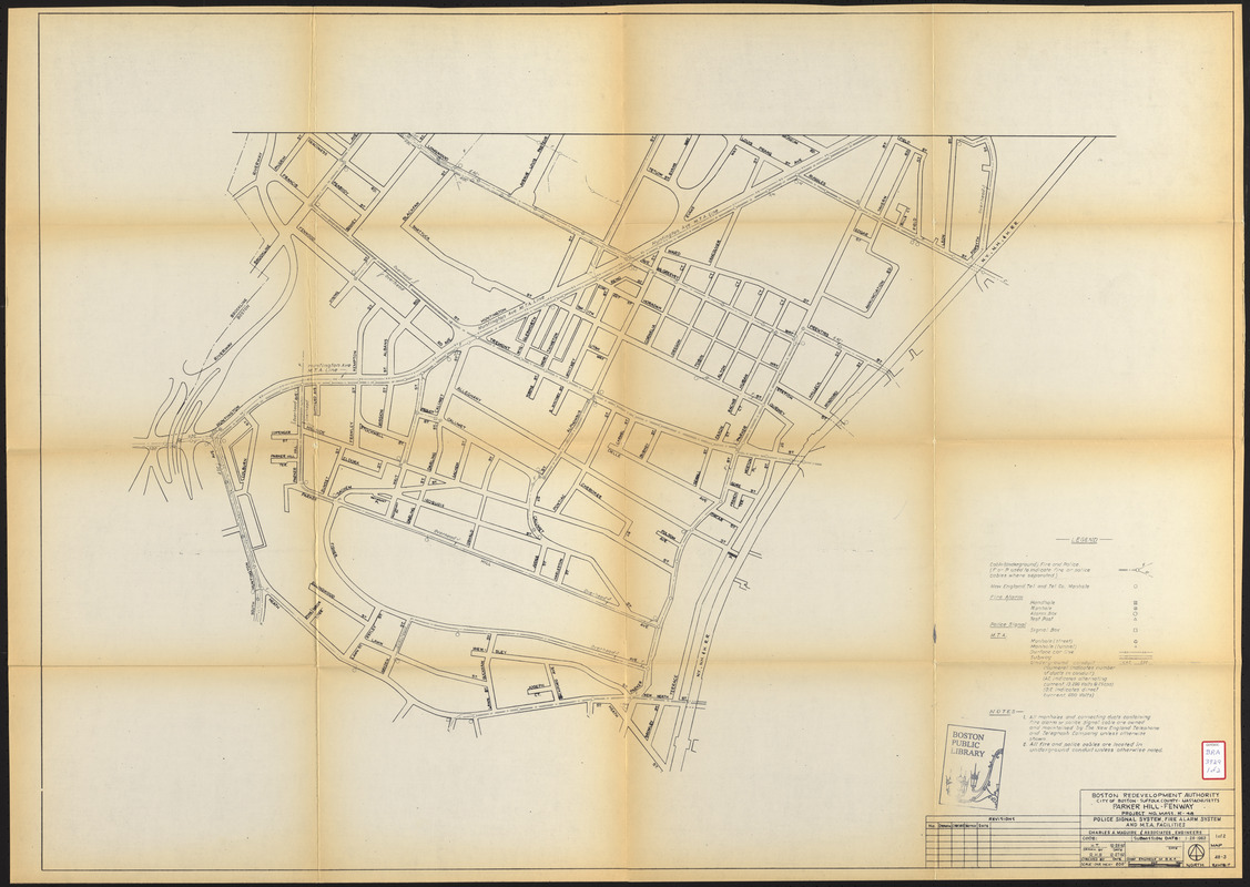
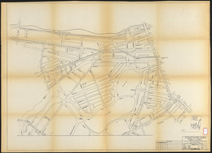
These maps depict the police signal system (signal box and cable locations), fire alarm system (handhole, manhole, alarm box and test post locations), Metropolitan Transit Authority facilities (manhole, surface car lines, subway and underground conduit locations) and the locations of the New England Telephone and Telegraph Co. manholes.
- Cartographer:
- Charles A. Maguire and Associates
- Publisher:
- Boston Redevelopment Authority
- Date:
-
January 28, 1963
- Format:
-
Maps/Atlases
- Location:
-
Boston Public Library
Central Library in Copley Square - Collection (local):
-
Boston Public Library Collection
- Subjects:
-
Fire alarms--Massachusetts--Boston--Maps
Manholes--Massachusetts--Boston--Maps
Police--Massachusetts--Boston--Maps
Street-railroads--Massachusetts--Boston--Maps
Subways--Massachusetts--Boston--Maps
Fenway (Boston, Mass.)--Maps
Mission Hill (Boston, Mass.)--Maps
City planning--Massachusetts--Boston--Maps
New England Telephone and Telegraph Company
Metropolitan Transit Authority (Boston, Mass.)
- Places:
-
Suffolk (county)BostonFens
Mission Hill
- Extent:
- 2 maps ; 84 x 117 cm
- Terms of Use:
-
No known copyright restrictions.
No known restrictions on use.
- Publisher:
-
[Boston] :
Boston Revelopment Authority
- Scale:
-
Scale 1:2,400
- Language:
-
English
- Table of Contents:
-
Map 1
Map 2
- Catalog Record:
-
http://bpl.bibliocommons.com/item/show/1034951075
- Identifier:
-
06_01_017214A
06_01_017214B
- Call #:
-
BRA/3929
- Barcode:
-
mq6331686


