Special plans to chart no. 394, western shore of the Caribbean Sea : from British surveys, corrected to 1872
Item Information
- Title:
- Special plans to chart no. 394, western shore of the Caribbean Sea : from British surveys, corrected to 1872
- Issuing body:
- United States. Hydrographic Office
- Date:
-
[1876]
- Format:
-
Maps/Atlases
- Genre:
-
Nautical charts
- Location:
-
Boston Public Library
Norman B. Leventhal Map & Education Center - Collection (local):
-
Norman B. Leventhal Map & Education Center Collection
- Subjects:
-
Coasts--Caribbean Sea--Maps
Nautical charts--Caribbean Sea
Providence Island (Colombia)--Maps
Serrana Bank (Colombia)--Maps
Laguna Gracias a Dios (Nicaragua)--Maps
Catalina Bay (Colombia)--Maps
- Places:
-
ColombiaProvidencia y Santa Catalina, Departamento de Archipiélago de San AndrésProvidencia, Isla de (island)
NicaraguaNorth Caribbean Coast (region)
Serrana Bank
Laguna Gracias a Dios
Bahía Catalina
- Extent:
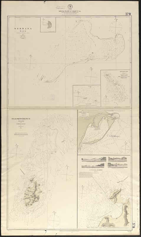
- 4 maps on 1 sheet ; 101 x 58 cm
- Terms of Use:
-
No known copyright restrictions.
No known restrictions on use.
- Publisher:
-
Washington, D.C. :
Hydrographic Office
- Scale:
-
Scales differ
- Language:
-
English
- Table of Contents:
-
Serrana Bank
Old Providence Island and Coral Bank
Cape Gracias Harbor
Catalina Harbor
- Notes:
-
Relief shown by hachures and spot heights. Depths shown by soundings and isolines.
Includes 3 insets and 4 coastal views.
Insets: North Cay -- South Cay Channel -- Rancador Bank.
Additions in red.
"Cor. (VII.76)."
"Cor. III.75."
Stamped "canceled."
- Notes (date):
-
This date is inferred.
- Identifier:
-
06_01_017080
- Call #:
-
G9096.P5 svar .U55 no. 395
- Barcode:
-
39999085953691


