Vermont from actual survey
This map is also available in American Revolutionary Geographies Online (ARGO), a collections portal especially built for material relating to the American Revolutionary War Era. Visit ARGO to learn more about this item and explore the historical geography of North America in the late eighteenth century.
Item Information
- Title:
- Vermont from actual survey
- Description:
-
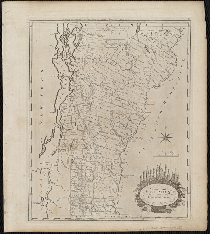
Among the maps Mathew Carey included in his atlases was one of Vermont, which joined the nation as the fourteenth state in 1791. Although his 1796 General Atlas was a world atlas, it included maps of the individual states and territories within the growing United States. This map of Vermont, delineated by Amos Doolittle, features the state’s mountains and towns, while the cartouche in the bottom right pays tribute to its forests. Carey’s General Atlas was almost twice the size of his Pocket Atlas and includes double the number of maps.
- Creator:
- Doolittle, Amos, 1754-1832
- Cartographer:
- Doolittle, Amos, 1754-1832
- Publisher:
- Carey, Mathew, 1760-1839
- Name on Item:
-
delineated & engraved by Amos Doolittle
- Date:
-
[1800]
- Format:
-
Maps/Atlases
- Location:
-
Boston Public Library
Norman B. Leventhal Map & Education Center - Collection (local):
-
Norman B. Leventhal Map & Education Center Collection
- Subjects:
-
Vermont--Maps
- Places:
-
Vermont
- Extent:
- 1 map ; 36 x 29 cm
- Terms of Use:
-
No known copyright restrictions.
No known restrictions on use.
- Publisher:
-
[Philadelphia] :
[Mathew Carey]
- Scale:
-
Scale approximately 1:670,000
- Language:
-
English
- Notes:
-
Relief shown pictorially.
Prime meridian: Philadelphia.
"Engraved for Carey's American edition of Guthrie's Geography improved."
In upper right margin: 25.
Map 25 in his Carey's general atlas. Philadelphia : Mathew Carey, 1800.
This map can be viewed as a georeferenced overlay in an interactive application made especially for We Are One: Mapping America's Road from Revolution to Independence http://d2o8owo4k087al.cloudfront.net/index.html?mapId=88.
- Notes (date):
-
This date is inferred.
- Notes (exhibitions):
-
Exhibited: "We Are One: Mapping America's Road from Revolution to Independence" organized by the Norman B. Leventhal Map Center at the Boston Public Library, 2015.
- Identifier:
-
06_01_004544
- Call #:
-
G1015 .C3 1800x
- Barcode:
-
30000005056490


