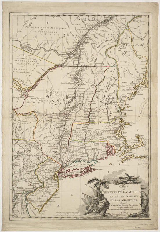
Carte du théatre de la guerre entre les Anglais et les Américains
This map is also available in American Revolutionary Geographies Online (ARGO), a collections portal especially built for material relating to the American Revolutionary War Era. Visit ARGO to learn more about this item and explore the historical geography of North America in the late eighteenth century.
Item Information
- Title:
- Carte du théatre de la guerre entre les Anglais et les Américains
- Creator:
- Brion de la Tour, Louis
- Contributor:
- Esnauts et Rapilly
- Name on Item:
-
dressée d'après les cartes anglaises les plus modernes, par M. Brion de la Tour, ingénieur-geographe du roi
- Date:
-
1777
- Format:
-
Maps/Atlases
- Location:
-
Boston Public Library
Norman B. Leventhal Map & Education Center - Collection (local):
-
Norman B. Leventhal Map & Education Center Collection
- Subjects:
-
Northeastern States--Maps--Early works to 1800
- Places:
-
Northeastern United States (area)
- Extent:
- 1 map : hand col. ; 76 x 51 cm.
- Terms of Use:
-
No known copyright restrictions.
No known restrictions on use.
- Publisher:
-
Paris :
Chez Esnauts et Rapilly
- Scale:
-
Scale ca. 1:1,200,000
- Language:
-
French
- Notes:
-
Relief shown pictorially.
Covers the area from Quebec to Cape May, N.J., and from the Kennebec River to Lake Ontario.
Shows boundaries, states, some counties, towns and cities, forts, roads, battlfields, and relief.
British troops are shown at Germantown and "Frank-Fort," Pa., and Saratoga, N.Y.
Includes some historical notes.
- Identifier:
-
06_01_000881
- Call #:
-
G3711.S3 1777 .B75
- Barcode:
-
39999052508890


