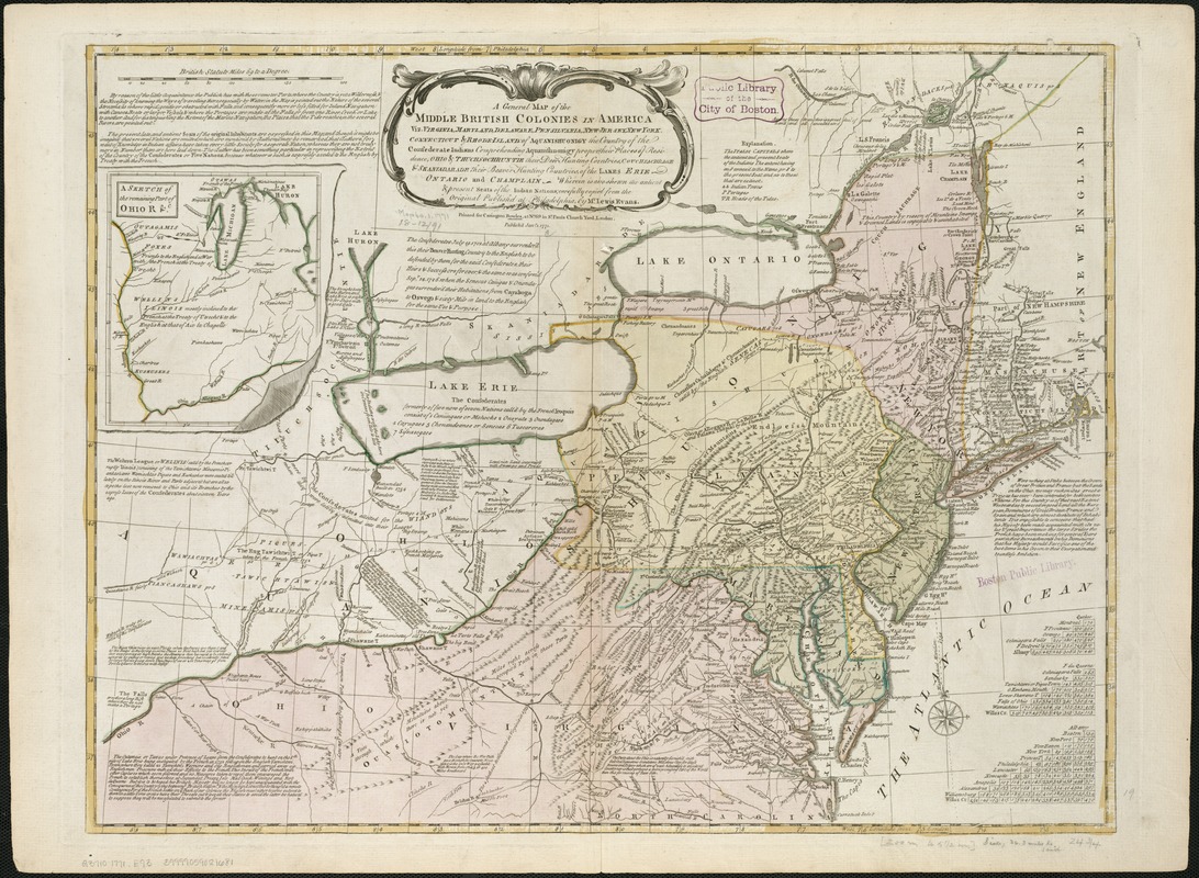
A general map of the middle British colonies in America, viz. Virginia, Maryland, Delaware, Pensilvania, New-Jersey, New York, Connecticut & Rhode-Island : of Aquanishuonigy the country of the confederate Indians comprehending Aquanishuonigy proper, their places of residence, Ohio & Thuchsochruntie their deer hunting countries, Couchsachrage & Skaniadarade their beaver hunting countries, of the Lakes Erie, Ontario and Champlain : wherein is also shewn the antient & present seats of the Indian nations
This map is also available in American Revolutionary Geographies Online (ARGO), a collections portal especially built for material relating to the American Revolutionary War Era. Visit ARGO to learn more about this item and explore the historical geography of North America in the late eighteenth century.
Item Information
- Title:
- A general map of the middle British colonies in America, viz. Virginia, Maryland, Delaware, Pensilvania, New-Jersey, New York, Connecticut & Rhode-Island : of Aquanishuonigy the country of the confederate Indians comprehending Aquanishuonigy proper, their places of residence, Ohio & Thuchsochruntie their deer hunting countries, Couchsachrage & Skaniadarade their beaver hunting countries, of the Lakes Erie, Ontario and Champlain : wherein is also shewn the antient & present seats of the Indian nations
- Creator:
- Evans, Lewis, 1700?-1756
- Name on Item:
-
carefully copied from the original published at Philadelphia, by Mr. Lewis Evans.
- Date:
-
1771
- Format:
-
Maps/Atlases
- Location:
-
Boston Public Library
Norman B. Leventhal Map & Education Center - Collection (local):
-
Norman B. Leventhal Map & Education Center Collection
- Subjects:
-
Northeastern States--Maps--Early works to 1800
Great Britain--Colonies--America--Maps--Early works to 1800
- Places:
-
Northeastern United States (area)
- Extent:
- 1 map : col. ; 49 x 64 cm.
- Terms of Use:
-
No known copyright restrictions.
No known restrictions on use.
- Publisher:
-
London :
Printed for Carington Bowles
- Scale:
-
Scale ca. 1:2,250,000.
- Language:
-
English
- Notes:
-
Relief shown pictorially.
Hand colored.
Shows "West longitude from London" and "from Philadelphia."
Differs from other copies in absence of Connecticut River north of "Great Falls." Also differs in coloration of boundaries: Ohio and Kentucky River are colored as boundaries; Pennsylvania extends north to a line at approximately 42⁰40ʹ; Maryland extends west to "Yochio Geni."
Includes text, historical notes, distance charts, and inset of "A sketch of the remaining part of Ohio R. &c."
- Identifier:
-
06_01_006249
- Call #:
-
G3710 1771 .E93
- Barcode:
-
39999059021681
- LCCN:
-
75693766


