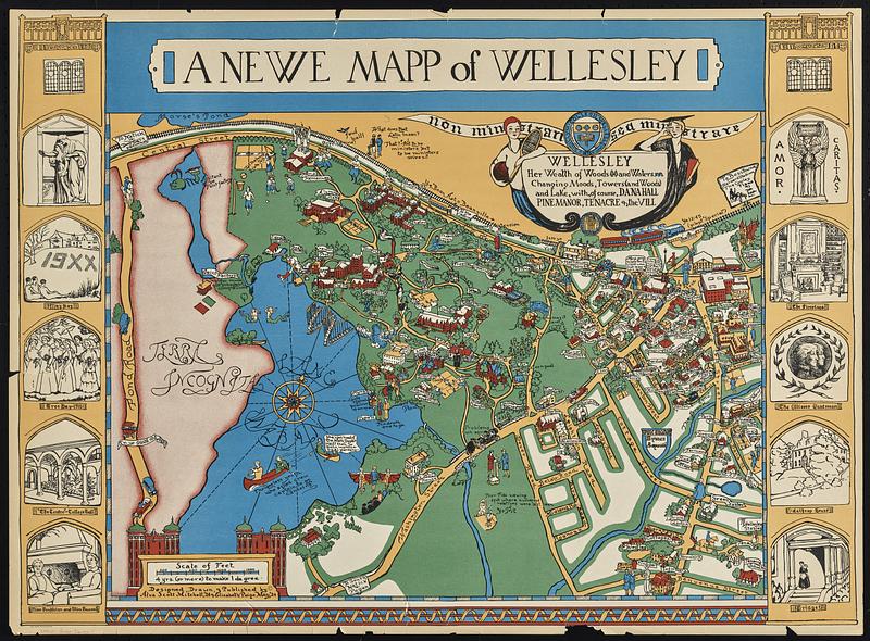
A newe mapp of Wellesley
Item Information
- Title:
- A newe mapp of Wellesley
- Description:
-
A pictorial map of the town of Wellesley, Massachusetts in the 1920s with humorous depictions of student life at Wellesley college. The map is bordered on the left and right by two twin towers featuring ten vignettes of campus sites and personalities. A cartouche in the upper right of map is flanked by a woman with a tennis racket and a woman in commencement dress. Above the cartouche is the Wellesley college seal and motto.
- Cartographer:
- Garfield, Alva Scott
- Cartographer:
- May, Elizabeth Paige
- Name on Item:
-
designed, drawn, & published by Alva Scott Mitchell '24 & Elizabeth Paige May '24
- Date:
-
[ca. 1926]
- Format:
-
Maps/Atlases
- Genre:
-
Pictorial maps
- Location:
-
Boston Public Library
Norman B. Leventhal Map & Education Center - Collection (local):
-
David Judkins Weaver Papers
- Subjects:
-
Wellesley (Mass.)--Maps
Wellesley College
- Places:
-
MassachusettsNorfolk (county)Wellesley
- Extent:
- 1 map : color ; 43 x 57 cm, on sheet 55 x 74 cm
- Terms of Use:
-
No known copyright restrictions.
No known restrictions on use.
- Publisher:
-
[Wellesley, Mass.?] ; Boston :
Alva Scott Mitchell and Elizabeth Paige May ; The Tudor Press
- Language:
-
English
- Notes:
-
This is one of the earliest pictorial maps by Alva Scott Mitchell who subsequently worked under her married name, Alva Scott Garfield.
Both artists graduated from Wellesley College in 1924.
- Identifier:
-
06_01_018858
- Call #:
-
Weaver folder 26 no.11