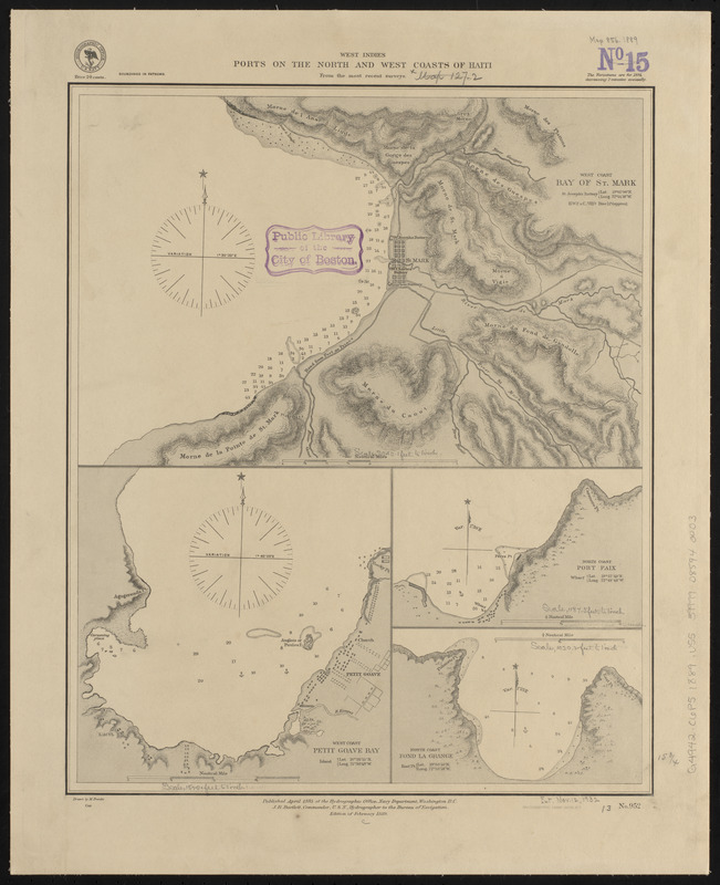
West Indies, ports on the north and west coasts of Haiti : from the most recent surveys
Item Information
- Title:
- West Indies, ports on the north and west coasts of Haiti : from the most recent surveys
- Title (alt.):
-
Ports on the north and west coasts of Haiti
- Issuing body:
- United States. Hydrographic Office
- Engraver:
- Franke, M. (Max)
- Printer:
- Leggo Bros. & Co.
- Name on Item:
-
drawn by M. Franke
- Date:
-
1889
- Format:
-
Maps/Atlases
- Location:
-
Boston Public Library
Norman B. Leventhal Map & Education Center - Collection (local):
-
Norman B. Leventhal Map & Education Center Collection
- Subjects:
-
Coasts--Haiti--Maps
Nautical charts--Haiti--Saint-Marc Bay
Nautical charts--Haiti--Petit Goâve Bay
Nautical charts--Haiti--Fond Lagrange Bay
Haiti--Maps
Saint-Marc (Artibonite, Haiti)--Maps
Saint-Marc Bay (Haiti)--Maps
Petit Goâve (Haiti)--Maps
Petit Goâve Bay (Haiti)--Maps
Port-de-Paix (Haiti)--Maps
Fond Lagrange Bay (Haiti)--Maps
- Places:
-
HaitiArtiboniteSaint-Marc
HaitiOuestPetit-Goâve
HaitiNord-OuestPort-de-Paix
HaitiDépartement du Nord
Baie Fond Lagrange
- Extent:
- 4 maps on 1 sheet ; 41 x 33 cm
- Terms of Use:
-
No known copyright restrictions.
No known restrictions on use.
- Publisher:
-
Washington, D.C. :
Hydrographic Office
- Edition:
- Edition of February 1889
- Scale:
-
Scale approximately 1:13,200
Scale approximately 1:13,200
Scale approximately 1:18,300
Scale approximately 1:36,200
- Language:
-
English
- Table of Contents:
-
West coast, Bay of St. Mark
West coast, Petit Goave Bay
North coast, Port Paix
North coast, Fond la Grange.
- Notes:
-
Relief shown by hachures. Depths shown by soundings.
- Identifier:
-
06_01_015740
- Call #:
-
G9096.P5 svar .U55
- Barcode:
-
39999085940003