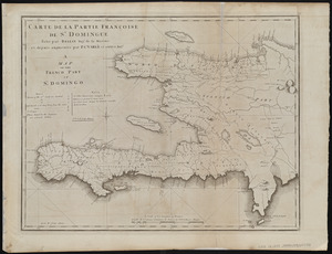
West Indies, Haiti or Santo Domingo, Cayes, Flamand, St. Louis and Meste Bays : from French government surveys to 1872, with additions from other surveys to 1876

Item Information
- Title:
- West Indies, Haiti or Santo Domingo, Cayes, Flamand, St. Louis and Meste Bays : from French government surveys to 1872, with additions from other surveys to 1876
- Title (alt.):
-
Cayes, Flamand, St. Louis and Meste Bays
- Issuing body:
- United States. Hydrographic Office
- Printer:
- Leggo Bros. & Co.
- Date:
-
1889
- Format:
-
Maps/Atlases
- Location:
-
Boston Public Library
Norman B. Leventhal Map & Education Center - Collection (local):
-
Norman B. Leventhal Map & Education Center Collection
- Subjects:
-
Coasts--Haiti--Maps
Nautical charts--Haiti--Cayes, Bay of
Nautical charts--Haiti--Flamand Bay
Nautical charts--Haiti--Great Mesle Bay
Saint Louis Bay--Haiti--Saint Louis Bay
Haiti--Maps
Cayes, Bay of (Haiti)--Maps
Flamand Bay (Haiti)--Maps
Great Mesle Bay (Haiti)--Maps
Saint Louis Bay (Haiti)--Maps
- Places:
-
HaitiSudCayes, Baie des (bay)
Baie des Flamands
Grande Baie du Mesle
Baie de Saint-Louis
- Extent:
- 1 map ; 48 x 64 cm
- Terms of Use:
-
No known copyright restrictions.
No known restrictions on use.
- Publisher:
-
Washington, D.C. :
Hydrographic Office
- Edition:
- Edition of March 1889
- Scale:
-
Scale approximately 1:73,300
- Language:
-
English
- Notes:
-
Relief shown by hachures and spot heights. Depths shown by soundings and isolines.
Includes coastal view of Vache Island.
- Identifier:
-
06_01_015744
- Call #:
-
G9096.P5 svar .U55
- Barcode:
-
39999085940045