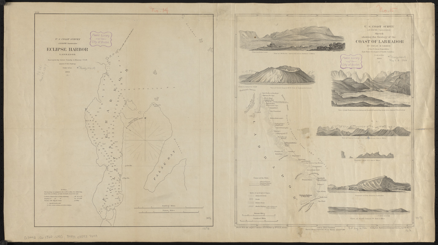
Eclipse Harbor, Labrador
Item Information
- Title:
- Eclipse Harbor, Labrador
- Title (alt.):
-
Sketch showing the geology of the Coast of Labrador
- Cartographer:
- United States Coast Survey
- Publisher:
- United States Coast Survey
- Surveyor:
- Murray, A.
- Cartographer:
- Lieber, Oscar M. (Oscar Montgomery), 1830-1862
- Cartographer:
- Maedel, J. W.
- Cartographer:
- McMurtrie, W. B. (William Birch)
- Lithographer:
- A. Hoen & Co.
- Name on Item:
-
surveyed by Lieut. Comdg. A. Murray, U.S.N. ; Sketch showing the geology of the Coast of Labrador / by Oscar M. Lieber ; geological representations and lettering by J.W. Maedel ; drawn from the original sketches of O.M. Lieber. by Wm. B. McMurtrie
- Date:
-
1860
- Format:
-
Maps/Atlases
- Location:
-
Boston Public Library
Norman B. Leventhal Map & Education Center - Collection (local):
-
Norman B. Leventhal Map & Education Center Collection
- Subjects:
-
Eclipse Harbour (N.L.)--Maps
Labrador (N.L.)--Maps
- Places:
-
CanadaNewfoundland and Labrador (province)
Eclipse Harbour
- Extent:
- 2 maps on 1 sheet ; 38 x 32 cm and 38 x 31 cm, on sheet 43 x 77 cm
- Terms of Use:
-
No known copyright restrictions.
No known restrictions on use.
- Publisher:
-
[Washington, D.C.] ; Balto. :
U.S. Coast Survey ; Lith by A. Hoen & Co. ; views in A. Hoen's Lithokoustic Process
- Scale:
-
Scale 1:60,000
Scale 1:5,000,000
- Language:
-
English
- Notes:
-
Relief shown by spot heights. Depths shown by soundings.
Eclipse Harbor map includes notes.
In upper left: No. 38.
Sketch includes 7 views: View of Mt. Bache, Aulezavik Island, distance 5 miles -- View of crater shaped mt. e. side of Aulezavik Island -- View of high peaks between Aulezavik Sound & Ungava Bay from near astronl. observatory --- View of coast of Labrador s. of Cape Niakungo, dist. 20 miles -- Mugford Island s.e. dist. 20 miles -- Entrance of Port Manvers, Labrador -- View of Battle Island w. dist. 4 miles.
- Identifier:
-
06_01_015537
- Call #:
-
G3442.C6 1860 .U55
- Barcode:
-
39999085937249