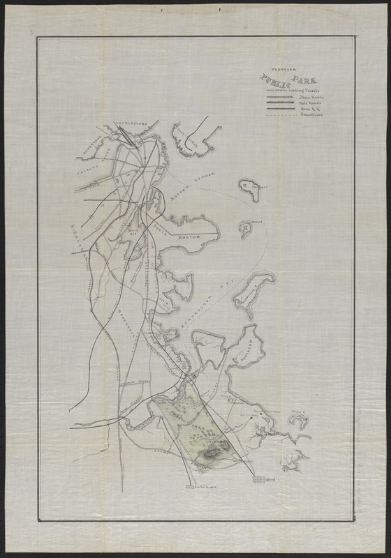
Proposed public park and routes leading thereto
Item Information
- Title:
- Proposed public park and routes leading thereto
- Date:
-
[ca. 1866–1872]
- Format:
-
Maps/Atlases
Manuscripts
- Location:
-
Boston Public Library
Norman B. Leventhal Map & Education Center - Collection (local):
-
Norman B. Leventhal Map & Education Center Collection
- Subjects:
-
Parks--Massachusetts--Quincy--Maps
Quincy (Mass.)--Maps
Manuscript maps
- Places:
-
MassachusettsNorfolk (county)Quincy
- Extent:
- 1 manuscript map : hand color ; 58 x 38 cm
- Terms of Use:
-
No known copyright restrictions.
No known restrictions on use.
- Place of origin:
-
[Quincy, Mass.]
- Scale:
-
Scale approximately 1:30,000
- Language:
-
English
- Notes:
-
Shows proposed park, main roads, railroads, horse-drawn railroads and steamboat routes.
Manuscript, ink and watercolor on coated linen.
Relief shown by hachures.
Date estimated from National Sailors Home, built 1866, and Old Colony & Newport Railroad, which became Old Colony Railroad in 1872.
- Identifier:
-
06_01_016068
- Call #:
-
G3764.Q6G52 1872 .P76
- Barcode:
-
39999085941688