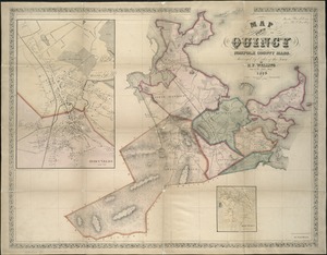
Atlas of the city of Quincy, Norfolk County, Massachusetts
Item Information
- Title:
- Atlas of the city of Quincy, Norfolk County, Massachusetts
- Title (alt.):
-
Atlas of the city of Quincy, Massachusetts
- Cartographer:
- Branch, Ernest W., approximately 1864-
- Name on Item:
-
compiled from the latest official plans and original surveys and published by Ernest W. Branch, civil engineer
- Date:
-
1923
- Format:
-
Maps/Atlases
- Location:
-
Boston Public Library
Norman B. Leventhal Map & Education Center - Collection (local):
-
Norman B. Leventhal Map & Education Center Collection
- Subjects:
-
Quincy (Mass.)--Maps
Real property--Massachusetts--Quincy--Maps
Landowners--Massachusetts--Quincy--Maps
Buildings--Massachusetts--Quincy--Maps
- Places:
-
MassachusettsNorfolk (county)Quincy
- Extent:
- 1 atlas (2 unnumbered leaves, 1 unnumbered double leaf of plates, 30 double leaves of plates) : 34 color maps ; 58 cm
- Terms of Use:
-
No known copyright restrictions.
No known restrictions on use.
- Publisher:
-
Quincy :
Ernest W. Branch
- Language:
-
English
- Notes:
-
Relief shown by hachures (index map on unnumbered double leaf only).
Double leaves 9, 22, & 26 each consist of 2 maps, with the halves of each double leaf labeled "A" and "B" (for example, 26A, 26B).
Includes index.
- Identifier:
-
06_01_018558
- Call #:
-
G1234.Q6 B73 1923
- Barcode:
-
39999085968871