Map of Connecticut River in the states of Massachusetts & Connecticut : in nine sheets

Item Information
- Title:
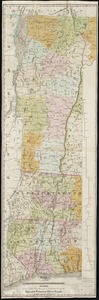
- Map of Connecticut River in the states of Massachusetts & Connecticut : in nine sheets
- Issuing body:
- Massachusetts. Connecticut Valley Waterway Board
- Surveyor:
- Board of Harbor and Land Commissioners of Massachusetts
- Name on Item:
-
compiled from surveys made by the United States Government and the Board of Harbor and Land Commissioners of Massachusetts, and other sources
- Date:
-
[1913]
- Format:
-
Maps/Atlases
- Location:
-
Boston Public Library
Norman B. Leventhal Map & Education Center - Collection (local):
-
Norman B. Leventhal Map & Education Center Collection
- Subjects:
-
Connecticut River--Maps
- Places:
-
Connecticut (river)
- Extent:
- 9 maps : color ; sheets 65 x 110 cm or smaller
- Terms of Use:
-
No known copyright restrictions.
No known restrictions on use.
- Publisher:
-
[Boston] :
[Connecticut Valley Waterway Board]||Heliotype Co.
- Scale:
-
Scale approximately 1:21,316
- Language:
-
English
- Notes:
-
Detached from Report of Connecticut Valley Waterway Board on an investigation of the Connecticut River (Boston : Wright & Potter Printing Co., 1913).
"Jan. 1913."
"Accompanying report of the Connecticut Valley Waterway Board appointed under the provisions of Chapter 149 of the Resolves of 1912."
Relief shown by contours. Depth shown by soundings.
- Notes (date):
-
This date is inferred.
- Identifier:
-
06_01_018785
- Call #:
-
G3722.C62 1913 .M37
- Barcode:
-
39999085969648